
In looking for my next winter activation, I came across Tom Dick and Harry (W7O/CN-032) which is on the upper portion of SkiBowl West.
Activation Reports

Submitted by KI7EMX on
Summit:
From Hwy 93, turn east at 42.06156, -114.67514. This is near mile marker 5 (5 miles north of the Nevada border/Jackpot). Take an immediate right and then left. Continue east up a well-graded road. The road begins to deteriorate after about a mile into deep ruts. A high clearance vehicle is recommended. The road eventually heads north. At approximately 4.9 miles from Hwy 93, make a right turn at a barbed wire cattle fence gate (42.07324, -114.63633). You’ll need to open the gate and put it back once you are on the opposite side. Head east along this less-maintained road.

Submitted by WU7H on
Summit:
We did this summit as a winter snowmobile trip with Cooper Mtn. and Poison Peak.
See full report here:
http://www.pnwsota.org/blog/wu7h/2022-march-04/cooper-mountain-wa-feb-2…
Submitted by WU7H on
Summit:
We did this summit as a winter snowmobile trip with Cooper Mtn. and Fox Peak.
See full report here:
http://www.pnwsota.org/blog/wu7h/2022-march-04/cooper-mountain-wa-feb-2…
Submitted by WU7H on
Summit:
WW7D and I set out on an adventure to see if we could activate Cooper Mountain via snowmobile. We knew that it was theoretically possible since Cooper Mountain lies on a groomed snowmobile trail. The only intel we had was a 7 day old trail grooming report. We knew from past experience that we might arrive to find the snow park gated or the trail impassible due to downed trees, lack of snow, etc. We decided to roll the dice and make the long journey from the Seattle area to Chelan, WA.

Submitted by WJ7WJ on
Summit:
Here is a pavement to trailhead activation if you find yourself in the Columbia River Gorge near White Salmon, WA. A short hike of 1 mile and 700 feet of elevation gain will get you the chance at this 2 pointer. The hike is mostly on a good gravel road and the last bit is easy cross country (for now) as they ran a cat over almost all of it, so not much to push through or step over. There are stumps around and a couple of tall “habitat trees” that are likely in the AZ if you need that sort of antenna support. I tied a pole to a stump at the top.

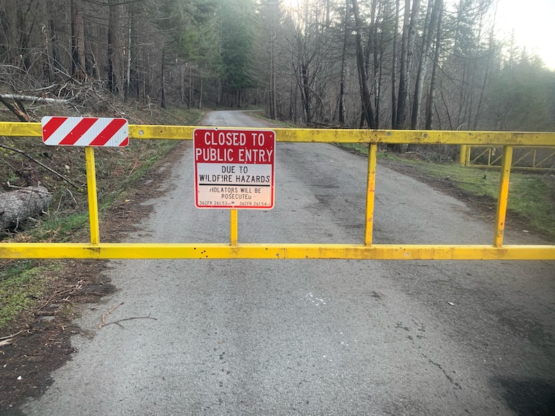
Submitted by K7WXW on
Summit:
A Forest Service map released in January, 2022 showed FR45 open to Goat Mountain so I drove out this morning, assuming I'd have, depending on the snow, a two to four mile snowshoe. Alas, about six miles before the trailhead (45.20082, -122.24825) I found this barring my way:

Submitted by N7KOM on
Summit:
A friend from Eugene wanted to hit Mount McLoughlin in the winter and despite the drive distance from Beaverton, it looked like too beautiful a mountain to pass up. After picking up rental snowshoes from REI in Medford I made it to the Summit Sno-Park TH at sunset. Casey arrived shortly after and we made some quick dinner on our backpacking stoves then turned in for the night.

Submitted by WA7JNJ on
Summit:
McMurray Benchmark is a 1-point summit located near I-5, just northeast of Stanwood, WA. I had driven by the entrance (where you turn north onto 12th Ave NW) in the past, but saw a no tresspassing sign and wasn't sure about driving up the road. This time, after I turned onto 12th Ave NW and drove 0.5 miles to the parking area... I was surprised at how many cars were parked at the trailhead. As long as you fill out the waiver form near the entrance, you are not tresspassing when you hike to the summit. Below is a link with more information about the area.
Submitted by KI7EMX on
Summit:
This was my second Winter activation attempt of this summit. The first one ended in an epic fail getting my Jeep stuck in the snow (see picture below). I had to do a self-recovery with my shovel and winch. Do not attempt to drive on the groomed "road." Though along the non-winter access road, this is a groomed "trail" for snowmobiles!