3020 (Receiver Mountain) is a summit for the persistent activator – you will find it has both good and challenging aspects. The approach roads require 4WD and most sections are in good shape but foliage in some sections of the road encroach and could scratch your vehicle. The final ascent to the summit is on an abandoned forest service road that has both good and some bad stretches to it. The summit is forested and consists of a sunny side with very heavy undergrowth and a shady side with easy hiking access under the canopy.
From either the North (i.e coming from Dusk Point W7W/SO-042) or the south, take FR-2350 to FR-2342 (at N47.38058° W123.40052°). The drive on FR-2342 gets narrow in spots but the road surface can be handled with a solid high clearance vehicle. At approximately N47.38504° W123.42512° the road will continue, but you want to park here. SOTA Atlas as well as my GPS showed FR-2342 going up to the summit, so I thought this was going to be a near drive up, but that route is no longer the “real” FR-2342. Look for the abandoned / blocked road to your right.
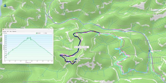
The hike from this point to the summit is 2.2 miles with 960 ft vertical. The abandoned roadbed is a mix of completely clear road sections, slightly treed sections and some that are completely overgrown and will frustrate you. When you get to an overgrown section, stay positive and know it is not too long; once you get through it, you are back on very easy sections.
There is a cliff face on your left-hand side as you near the summit. It blocks a direct bushwhack to the summit. I stayed on the road winding all the way around to the Northwest side of the summit and the ridgeline to the summit is easily accessed from the roadbed without having to go straight up or do any tough bushwhack. It’s an easy, short hike up the ridgeline to the “two faced” sunny-shady summit I described earlier. There is not much undergrowth on this shady side. Once you get to the summit proper you will see how the sunny side has dense nearly impassable growth. I stayed on the shady side and had no issues getting a mast up to set up HF under the tree canopy. I used a J-Pole on FM and random-wire end fed for HF.
I forgot my cell phone in the car so no summit pics on this one and can’t report about cell coverage, but I wouldn’t count on it here. There is, however, a very solid APRS capability in this area. Both Dusk Pt and this summit had full two way APRS. So I used my GPS for my clock to log, and APRS to spot.
GPS track shown below - Dark blue is my hike, light blue my drive, magenta was my planned route.


