The first of three activations in a weekend - if you can activate this one, I recommend several other peaks in the area as well. This was a first activation, so subsequent attempts may find better routes.
I planned a weekend with three summits in a day, and by all accounts probably could have managed if it weren't for a few things.
Getting there:
First, note that I took NF54, a paved road, to NF42, a well-graded gravel road, to NF37, which is a dirt road overgrown with branches, of a quality better suited to a three- or four-digit forestry road. Also, note that where NF37 meets one of the tributary streams of Crater Creek, it would cross the creek on a bridge, for which a good square run-up and foundation exist, but unfortunately the bridge does not. Instead, a very high-clearance vehicle (OHV, lifted truck, or the kind of Jeep for which Jeep tracks are named) could make this. They may have fixed it by the time you read this! By all accounts a bridge would fit there quite nicely! You may however be able to approach the other side by taking NF426 to circle the "massif".
Second, we expected a bushwhack of 500' from the saddle, but instead followed 3700-423 up from NF37, and bushwhacked from there. This route had substantially more distance than the original plan, but it was shorter than our planned route from the north.
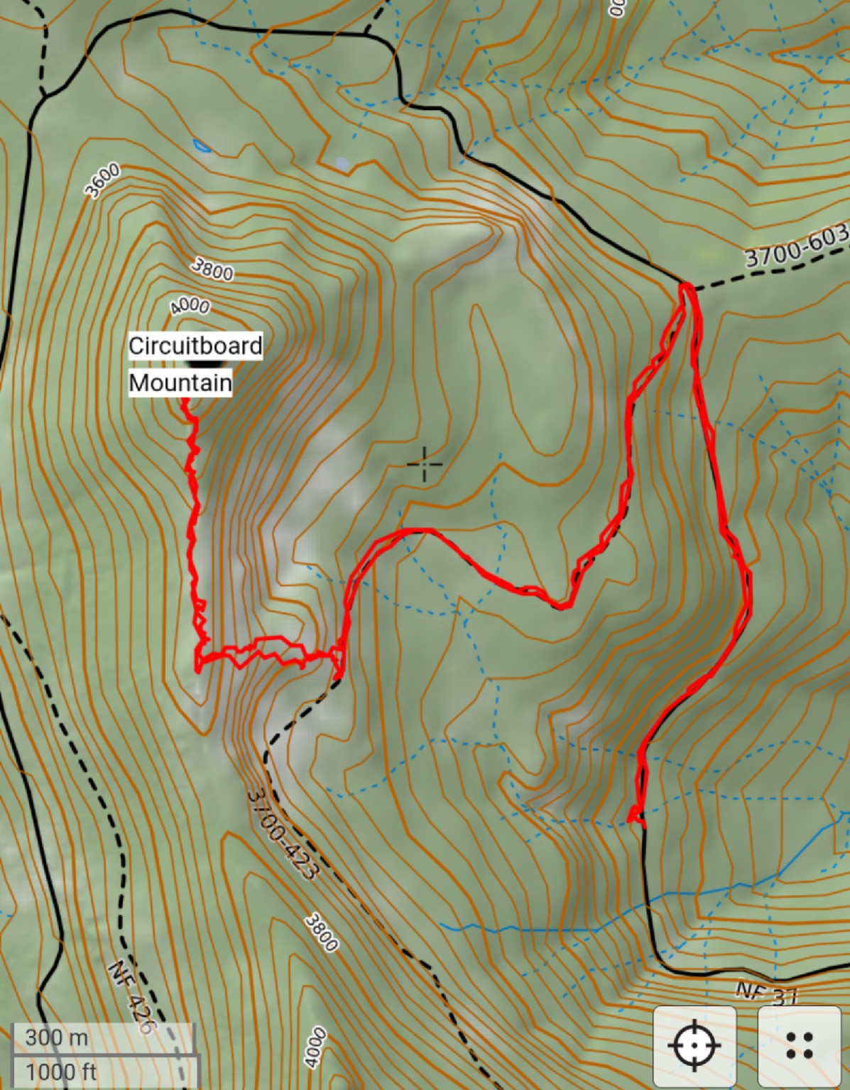
The climb:
So, some highlights - this track has been walked before, with boot prints plainly visible ahead of us. Bear in mind (sorry) that we also saw scat and bear tracks on this trail. Also keep in mind that this is not a trail by any stretch of the imagination - you will be bushwhacking from the edge of the marked road.
We hiked from the lack of a bridge to the summit. We hiked 37 to 3700-423, finding an open gate near this junction, and left the road where it circled a flattish spot some 80' above the road, visible on topo markings. There is no great way up to this spot, but you can pick your way up the slope with care. The flattish spot is very recognizable - it is an open meadow of bunch grasses or similar. Proceed through this to intermittent trees, blueberry bushes, and rocky slopes. This part is also steep, but less frequently a scramble.
I have no particular recommendations for what to follow, other than that the easiest path through the brush is probably the best one. Our track seems to match with other climbers', so feel free to use it as a guide - we simply followed the lowest angle approach to the ridge, then headed north. Once on the ridge, expect more trees, blueberry thickets, and downed logs til you get near the summit. The slopes are covered with wildflowers, and a trail becomes obvious in places, leading around some of the thick parts.
The summit itself is not majestic - you keep going up the ridge gradually until you realize it doesn't continue to go up. There would be some good views to the east, due to the steep slope and lack of trees on that side, but the trees are thicker west. You should see Trout Creek Hill and Soda Peaks from there, as well as possibly peaks in the Indian Heaven wilderness in the distance.
After a decent but quick activation, we headed down again. It's easy to miss the spot where we made the ridge, so just keep in mind where the road will be as you descend, and do preferably have a GPS with you. The hill is surrounded by roads so you'll inevitably find some navigational aid sooner or later, but you could easily get into trouble that way. It's better to come down the way you came, to avoid encountering a spot too steep to navigate.
There are easier peaks in the area, but I wouldn't overlook this one if you're feeling adventurous - however, Green Lookout (W7W/LC-062), Twin Rocks (LC-057), Soda Peaks (LC-052), Trout Creek Hill (LC-120), and Bare Mountain (LC-061) all offer easier hikes, with Soda Peaks having a trail nearly to the AZ, and Trout Creek Hill having a road to the AZ that is sedan accessible most of the way up (barring downed trees). Please consider this overlooked hill, once I give it a name ...