Summary - Getting 4340 into the log requires a two hour drive, a short steep, brush covered cross county hike to the summit, and HF capability. A map and compass or GPS is a really good idea, as are trekking poles and long pants. There is no trail to the summit and on the way up you will encounter a lot of very large deadfall along with stands of manzanita and poison oak. 2M contacts are difficult unless other SOTA ops are working on nearby mountains, APRS works well, and ATT messaging sometimes. If you are ambitious, 4340 can be done along with 4220 and Lookout in a single trip. You will definitely earn your four points getting to the top of this one.
Long Version - 4340 (SOTA name: Mount Continuity) is one of a cluster of summits west of Stabler, WA. I did 4340 and 4220 (SOTA name: D Layer, LC-067) together and if you don't mind a long day or are good at quick activations, you can add Lookout (LC-066) to the mix and rack up twelve points in one outing.
After checking three potential access points, I decided to hike up from the Zig Zag Lake trailhead (45.84637, -122.11100) as it didn't involve scrambling up a steep embankment through heavy brush, at least at the same time. The summit is south of the trailhead and the hike is approximately a quarter mile with 300' of elevation gain. Trekking poles and good shoes are a must, as is setting a waypoint for your vehicle location, given the deadfall and brush to be havigated.
Getting to the trailhead is straightforward. The drive from SE Portland is about two hours, split evenly between paved and unpaved road time. I recommend a 4WD vehicle with a bit of clearance as the roads get progressively rockier, more washed out, and narrower as you go further back. Long portions of the forest roads combine breath taking drops on one side and a lack of turnouts. Finally, you just doing 4340, there may be an easier way to get there; this route is designed to get Lookout, 4340, and 4220 in one trip:
GPX tracks to lookout, 4340, and 4220
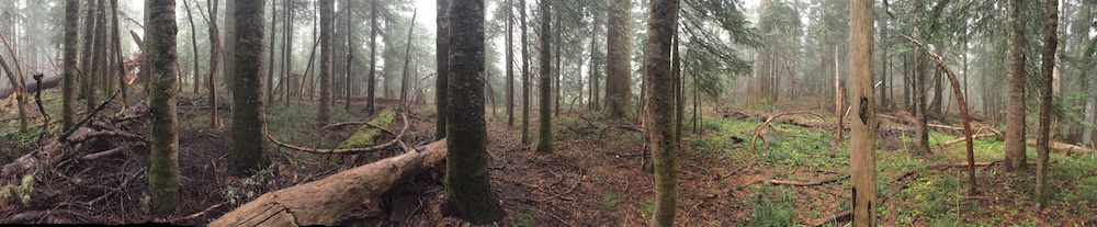
The summit itself is densely forested and probably without views but it was hard to tell because I was sitting in a cloud the whole time I was up there. Here's what it looked like from my operating position:

The only 2M contacts I made, even with a j pole, were with other SOTA ops on nearby summits. I might have done better with a beam pointed at Portland but who knows given that the summit is densely forested. There were plenty of places to hang wires for antennas and HF contacts were plentiful.
So... 4340 is a long drive from Portland over often rough forest roads, involves a cross country hike through brush, poison oak, and deadfall, isn't great for local QSOs, and doesn't have much to recommend it, view-wise. I wouldn't recommend it as a destination summit but done with one or more of its neighbors, it is a worth hiking.