Home is Tacoma, WA, but since I acquired lightweight QRP gear a couple of years ago, I’ve been tempted to take it with me when I travel. I finally did so, on a trip to visit family in New England.
Background
“Western Mountain”, W1/DI-002, is the western-most and least-activated SOTA peak of seven in Acadia National Park on Mt. Desert Island in the state of Maine. This peak is also very easy to get to from the town of Southwest Harbor, where my YF and I were visiting. The Mill Field trailhead, starting point of the Sluiceway Trail, is less than 4 miles driving distance (10-15 minutes driving time) from the center of town.
Sources do not all agree on names, but taking them together I find there are actually 4 western mountain peaks in Acadia, situated between Seal Cove Pond on the west and Long Pond on the east, all connected by the Bernard Mountain Trail (and an eastward extension to Mansell). The peaks are in some cases separated by named gaps, and in order from west to east these features are:
- Western Mountain (?, ~1000 ft)
- Bernard Mountain (1071 ft)
- Little Notch (gap, 890 ft)
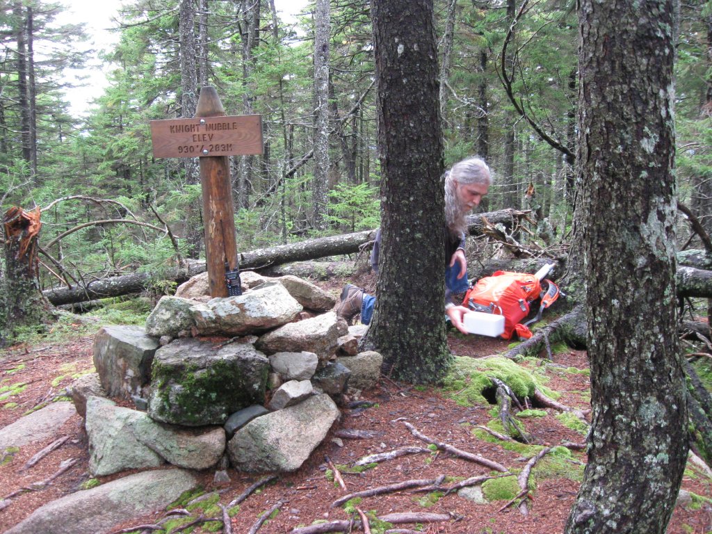
- Knight Nubble (930 ft)
- Great Notch (gap, 640 ft)
- Mansell Mountain (949 ft)
The coordinates of SOTA peak W1/DI-002 do not actually correspond with the peak named Western Mountain. In fact, the only place I could find an actual peak by that name was on Google Earth. The SOTA peak is more in the vicinity of Knight Nubble, on the eastern side of Little Notch. Knight Nubble is 140 ft lower in elevation than the nearby (within 1000 ft) Bernard Mountain peak. A previous activator, Scott W1ZU, had been there only a couple of weeks before and had also decided to use Knight Nubble as the activation site. I corresponded with him in advance of my trip, and his trail notes were very helpful. As Bernard is the tallest, one could argue that it should be the site of activations, and the effort would have been very similar, involving a left turn rather than a right at Little Notch and only a little more distance and climbing from that point.
The Mill Field trailhead is the terminus of two trails. The Bernard Mountain Trail (also called the South Face Trail by some maps and guides) starts to the left and heads generally west before climbing and looping north and easterly to traverse the peaks and gaps mentioned above. The Sluiceway Trail, to the right, heads more directly north up to Little Notch and affords a much shorter route to Knight Nubble. The first half mile climbs gently and meets a side trail that connects to the more-or-less parallel Great Notch Trail, which is only 0.1 mile to the east at this point (a ridge topping out at Knight Nubble separates the two). North of this junction, the Sluiceway Trail climbs steeply for another 0.4 miles until it meets the Bernard Mountain Trail at Little Notch. Knight Nubble is then only a very short jog to the east. These trails and the route to the trailhead are well-documented here:
http://www.citrusmilo.com/acadiaguide/bernardmountain.cfm
However, note the topo map at this source names the peak just west of Little Notch as “West Peak”, when other sources call this peak “Bernard”.
Activation
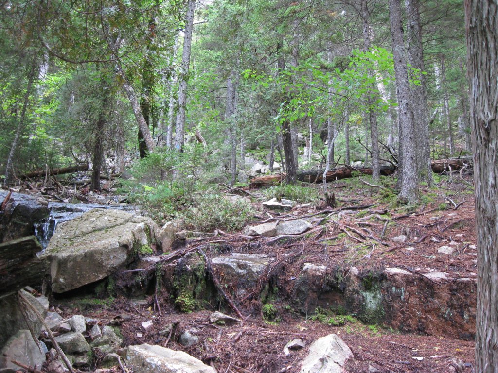
Starting at about 2PM, under a mostly cloudy sky, my brother, my YF and I took the Sluiceway Trail, which is marked with blue blazes at intervals on trees and rocks. Sometimes the blazes are a little far apart and the trail is not always obvious, so I wondered if we were still on it, but we always ended up finding a mark and proving intuition correct. Most of the trees are smallish red spruce of a uniform size, and the rock is granite.
On the initial leg, we bushwhacked around one large, fallen tree that obstructs the trail and has not been cleared. Past the eastward connector to Great Notch Trail, the Sluiceway Trail became quite steep, gaining about 550 ft of elevation in 0.4 miles. Much of this portion is ephemeral streambed, and since it had rained a great deal the previous day, there was water running in, and in some cases audibly under the trail. In one place, an elegant series of stone blocks has been placed to form a very helpful staircase. At the same spot, a second staircase was visible on the other side of the stream and leading west on some now-obscured and forgotten trail.
At Little Notch, we turned right onto the Bernard Mountain Trail. Knight Nubble, with its marker set in a small cairn of stones, was only a short distance and another 40 ft of elevation further.
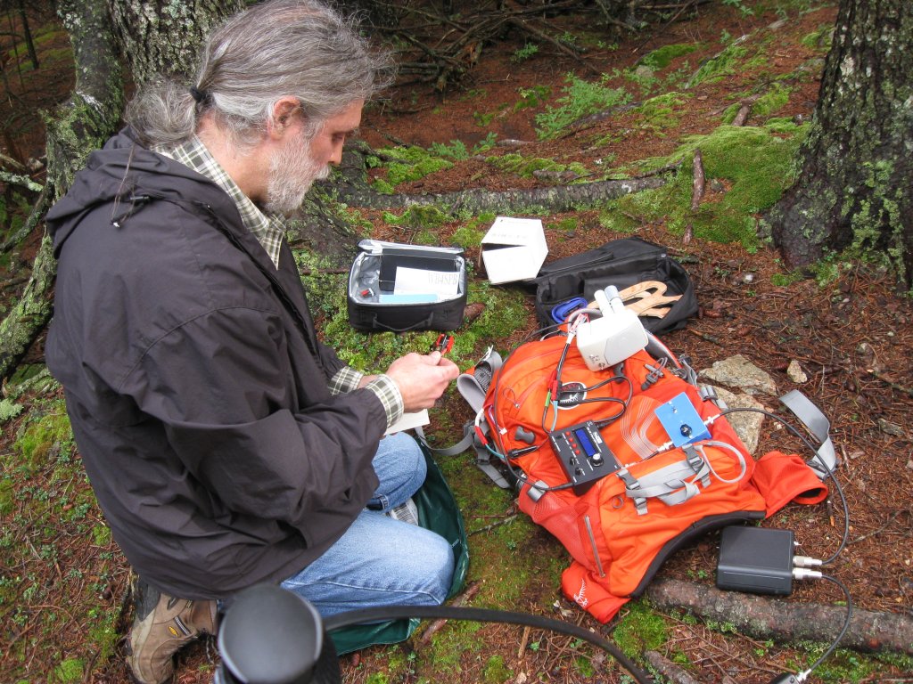
A bit after 3PM, I lashed my 20-foot collapsible fishing-pole mast to a very convenient red spruce stump, broken off a couple feet above the ground. I raised the 44 ft doublet with the wires running north and south (hoping to get some east-west pattern on 20M and work friends in the PNW), then I set up my HB1B, Z-817 tuner, and 1:1 balun. And… I discovered the tuner wasn’t working. I later concluded the batteries had been drained due to incautious packing: the soft case containing my equipment, subsequently placed in my suitcase for the flight east, probably allowed the “tune” button to be depressed for an extended period of time. (I’ve been thinking of trying an Emtech ZM-2 tuner, which would reduce my equipment count and complexity, so more grist for that mill.)
The Z-817 uses latching relays that don’t readjust until RF is present, and the last use of the tuner had been on 20M with the same antenna, so I discarded plans to operate on 40M and 30M and just gambled that it would match well enough on 20M.
After a few anxious minutes of no response to my CQs, I finally got a reply and then a string of 11 QSOs in about 25 minutes, working stations in MN, MO, CA, AZ, NM, IN, AL, FL, and Germany (wow!). Alas, I heard no one from home in the PNW, and I was later told they couldn’t hear me either.
I had timed the excursion for midday pacific time, and with the overcast and surrounding forest, the light was looking pretty gloomy by 4PM eastern. I briefly picked up my 2M HT with hand-held, half-wave vertical, and I made one additional QSO on 146.52 FM, adding ME to the states worked. Then I packed up.
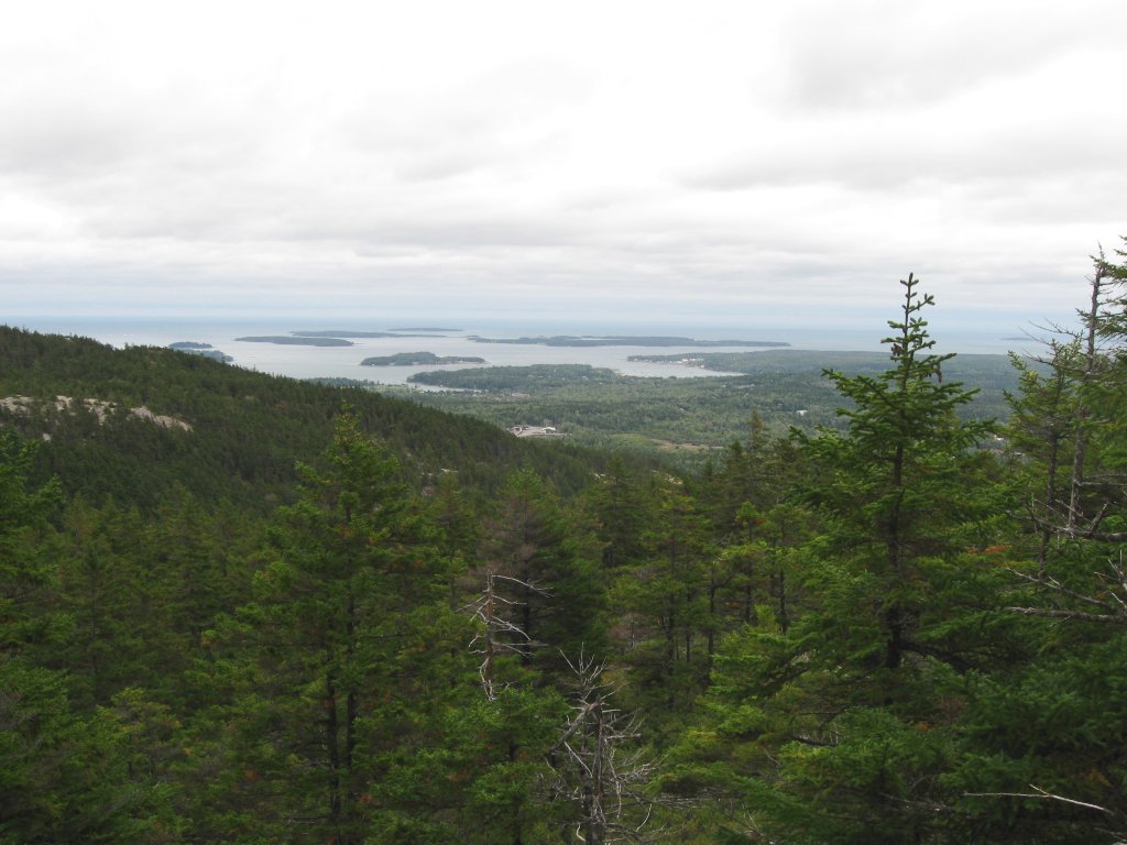
The rest of our party had been wandering around while I played radio, and my YF had discovered an overlook 3 minutes down the Bernard Mountain Trail in the easterly direction (opposite the way we came). We took that short hike to enjoy a scenic view of Southwest Harbor, the only view we encountered on these otherwise wooded trails. Then we decided that, instead of retracing our steps, we would continue east to Great Notch and take the Great Notch Trail south to the connector that would lead back to the lower portion of the Sluiceway Trail.
Some sections of the descent to Great Notch are like climbing down a cliff. In two places we had to hold onto saplings and roots to descend almost vertically. A relatively flat area between the two steep spots was lovely with moss and quiet pools of water. In due course we met the Great Notch Trail and headed south, again over a lot of ephemeral streambed much like Sluiceway, but not as steep. At the junction of Great Notch Trail and Gilley Trail, we took a third way to the right: the connector that quickly put us back on the lower portion of the Sluiceway Trail and finally back at the trailhead at 5PM.
Very fit persons can probably reach W1/DI-002 from the Mill Field trailhead in 30-45 minutes via the Sluiceway trail. Our unhurried trek through this very pleasant wood took a good hour, during which we saw no sign of other people. Summer hikers have reported annoying bugs, but we encountered none at all. With the occasionally dodgy footing, proper shoes are essential, and a good sense of balance is recommended. Note that the roads to the trailhead are closed between November and spring.