There are thirteen mountains in the W7W association with "Lookout Mountain" in the title. This report is about the only "Lookout Mountain" located in the Pacific-Lewis (PL) region, situated in national forest lands fairly close to the Paradise entrance to Mount Rainier National Park. The summit is a short, easy hike up a ridge, with some spectacular views along the way. What's the catch? The road to the trailhead is rough and developing a washout.
The summit is located about two miles SSE of Longmire Washington, and about 9 miles NNW of Packwood Washington in the Mt. Baker-Snoqualmie National Forest quite close to the NW edge of the Tatoosh Wilderness. The summit is is 6.3 miles east and slightly north of the popular High Rock (W7W/PL-021) lookout site. Lookout mountain is 5,476' tall, and a road gets you within about 500' of the summit.
Getting there: From Elbe, WA, drive 7 miles east, through Ashford, and turn right (south) onto Kernahan Rd. (also NF-52). Follow this road across the Nisqually River. The road makes a sweeping left turn to the east and is renamed Skate Creek Rd (but still called NF-52). After following NF-52 for 9.2 miles, there will be an intersection with FS-5230 at 46.7572, -121.9814 (ele. 2,460'). Continue onto FS-5230 for 6.4 miles to 46.7158, -121.7869. There, you will be at a high-point in the road at 4,960' and you will see the start of a forested ridge rising to the east. There is plenty of room to park in a dispersed camping site on the west side of the road.
More about FS-5230: The road has plenty of potholes, deep ruts, rocks and, occasionally, fallen trees on it. A high-clearance vehicle is recommended. The road gets a modest amount of traffic; there were at least two other vehicles on the road the day I was there. Once caution about the road: there is a washout developing about half way up FS-5230. It wasn't a problem for me on a motorcycle, but I came across that washout as an SUV was slowly and carefully driving past it, hugging the "good" side of the road without scraping off (much) paint. Obviously, narrower vehicles will haven an easier time navigating the washout. Motorcycles and e-bikes should have no difficulties.
Snow remains on the road well into summer. The first time I did this summit was with John, K7JRO, 25 Jun 2020. We ran into impassible snow about a mile from the summit, and walked up the road to the trailhead. Interestingly, we found evidence of snowmobile activity near the trailhead, so the summit might be doable in the winter with the right equipment....
The Hike: From the parking area, walk back along the road a couple hundred feet with the ridge on your right. You will find a convenient place to scramble a few feet up to the ridge. Continue up the ridge, staying right on top when you can. A boot path will frequently be visible and you can follow it until it disappears. There are a few places where the trail, geography or flora takes you below the ridge. Always descend on the less-steep south side of the ridge, and make your way back to the ridge top as soon as you get around the obstruction. There were two rocky knobs to go around or over, but otherwise, the trip up the ridge is straightforward. Total elevation gain is a bit over 500' in 0.5 miles (i.e. 1 mile round trip).
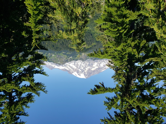
The Summit: The summit is moderately large, with plenty of room for setting up one or more stations or antennas. It is lightly treed, which makes it a bit of work to find unobstructed views. But there are views. Nearby Mt. Rainier is the real gem here, but views of the Tatoosh range, and views to the south are certainly rewarding. The worst aspect of the summit on my trip was the relentless mosquitoes and biting flies.
Here is a view of Mt. Rainier from one of the rocky knobs near the summit: