Signal Butte has been on my watch list for over a year and I was finally able to summit and activate it today. This peak had never been activated. Thanks to Nick KI7PTT for humoring me and coming along.
Directions: Follow Hwy 224 off I-205 to Ripplebrook, OR. At approximately 7.4 miles, turn left onto FS-57. Continue East on FS-57 to FS-58 (Shellrock Road). Bear left onto FS-58. Continue on FS-58 for approximately 7 miles to the intersection with NF-4610 (Abbott Road). I was pleasantly surprised to find that FS-57/FS-58 were paved from Ripplebrook to the NF-4610 intersection. Turn left onto NF-4610. This road is NOT for low clearance vehicles. The road is not steep but peppered with high rocks that protrude out of the road surface. NF-4610 turns into NF-240 (Indian Ridge Road) after 1.3 miles. Continue on FS-240 for approximately 2 more miles (a total of 3.3 miles from NF-4610). “You will see a small pull-off on the right side with a small game trail heading up into the woods.” (from Austin Smith – Peakbagger.com)
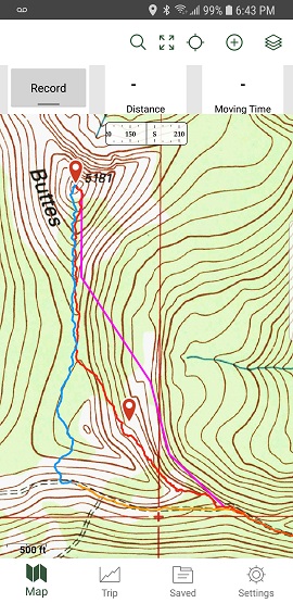
Note: We did not begin our hike at this location. See attached screen shot. The magenta line was the planned route. The ascent route (red) was steep, very overgrown and had multiple rock scree crossings. The descent route (blue) was much less aggressive. The orange line was the road walk back to the vehicle. Beginning and ending where described by Austin Smith (quotes above), just West of the blue line would have been better ascent starting and descent ending points!
The total ascent was 1.07 miles (55 minutes). The last ¼-mile is a stable scree scramble to the summit. The descent was .8 miles (35 minutes).
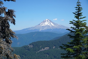
The summit views are some of the best I’ve seen in all my SOTA activations. Hood, Adams and St. Helens to the north and Jefferson, Three Sisters and Broken Top to the south. Had the sky been clearer, I’m sure we could have seen Rainer to the north.
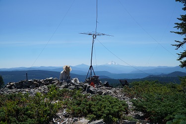
The summit has trees for antennas and rocks for ballast (lots of rocks). The air waves seemed quiet, though the QSO’s were strong and clear. Would I return to activate this summit again – probably not. It’s a long way from home (Forest Grove) and the effort was immense!