Quick notes: I have Google Fi, which uses T-Mobile and Sprint. Cell service is great, if you have a view to the northeast. Otherwise, it dies, and quickly. This was obvious when I was trying to stay in contact with people throughout the hike, leading to cutting in and out throughout the trip. I got it into my head to try a 4-pointer with no activations, and I saw a prime candidate, of only .7 miles with a gain of only a few hundred feet! What a find! Only problem is, there's no trail. Well, that's no problem! I'll just bring a friend, two cellphones, compass, map, maybe a beacon, who knows. But I set a day, and I couldn't find anyone to join me, so I set out with my phone GPS and my compass and headed up to try to activate this peak alone. I don't really recommend this; take a friend with you. Take a beacon. Always take a map, but that should go without saying.
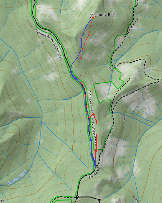
Take OR-224 to Estacada and through to Ripplebrook, then turn left on NF-57, then left again on NF-58. NF-57 is a proper two-lane paved highway, the typical forest arterial road, which leads to Timothy Lake. NF-58 is a 1.5-lane paved road that continues on pavement practically to where I started my hike. When 58 hits a tee, and a sign points east, to the right, marked NF-58, turn left instead, and follow the pavement up for NF-4610, signs to High Rock. Then, the pavement ends into a gravel road, and there is a dirt road to the left; that dirt road is the continuation of NF-4610. I went straight, and when I realized I took the wrong fork, I backed up until I saw a side road on the left. Turns out, this is a short road into a campsite, which goes up a hill and abruptly ends, but I didn't know this, so I valiantly headed out along the "road", and quickly lost it. After .4 miles of this, I realized that, without a reference path I could easily get back to, I could not safely return without a GPS. (I could, in fact, have followed the ridgeline pretty easily, but this is a little annoying, and the road makes a much better marker.) I decided to head down the hill, and try to find the road, and only if it were there would I feel comfortable proceeding. Well, that's when I realized that I had just taken a wrong turn, because this road is a lovely straight walk along level ground, and it takes you more than halfway to the peak from where I parked. It's also a well-graded dirt road, a little mucky a mile in, but driveable with an off-road vehicle. Knowing I had this as a reliable, unmistakable reference, I knew I would always be able to find it again from any point on this hike. So I went ahead with my plan - summit the peak! You won't have cell service til this point. Turn right off the road, and head up the hill into the saddle, which will give you a view of some cell towers. Proceed up and to the right of the ridgeline, traveling more overland than up, but still working up towards the peak. You will encounter a few stands of rhododendrons and some rock fields (or snow fields, as I did) but it's mostly thin undergrowth with few short trees to get in your way. This is a reasonably easy hike if you are confident in your hiking skill and you pay attention to where you are going, and you take a friend to make sure you make it out if you hurt yourself. It's short, it's easy, it's no sweat, but it was lonely and a bit scary for my first time off-trail alone. The peak is a pile of exposed rocks, extending up about 30 feet, but with a small stand of trees at the summit, and a ring of brush like a picket defending the peak. I carried my pack to the top, and set up in the trees, which were somewhat of a shield from the wind, but you may want to stay down from the peak if you have the means to do so and propagation favors you. DO carry some sort of backup emergency communication. You can probably complete this hike solo without a beacon, without excessive risk, if you're carrying a cellphone and two different radios, but don't put yourself unnecessarily in harm's way.
You will probably not see a single human being from the time you park to the time you get back to your car. You will almost certainly not see a single human being from the time you leave the road to the time you get back to it. Plan accordingly, and don't forget a map and compass - the direction of "flat" and a compass will get you back to the road with no trouble, and the road is an easy, comfortable walk out. If you've never gone overland without a trail, take a friend with you and you will have a really pleasant hike.