This summit is attained in a 4.5 mile, 3500 ft elevation gain hike with well maintained trial for the first half and reasonable trail with loose rock the rest of the way to the top. The trail head is easy to find once you know what you are looking for. There are a few key GPS waypoints that ease your way tremendously. I would not have been able to make this activation without tips from KC7DM, so a huge thank you to him.
I spent the night before the activation in Enterprise, OR and was at the trail head at 6:40AM, this allowed time for the hike to Traverse Ridge and also Ruby Peak which are across from each other. I was back to the trailhead at 4:45PM.
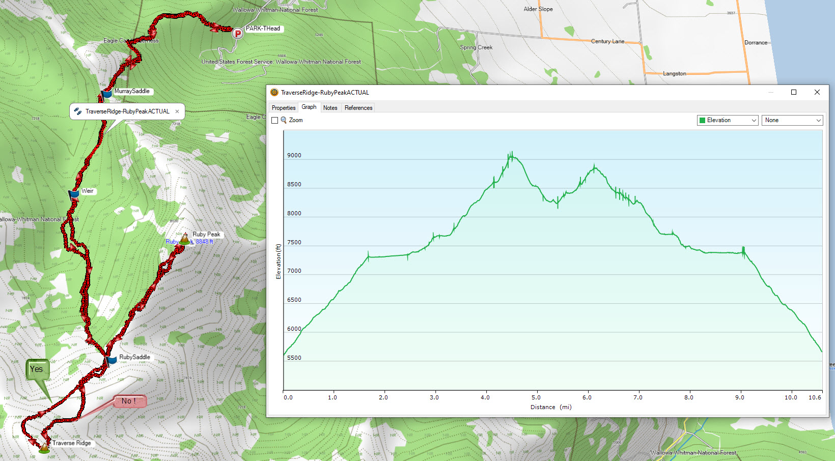
The trail head is located on Lime Quarry Road at 45.37808, -117.35148. I used Google maps to navigate to Lime Quarry Road. After the road turns to gravel continue on it. When it turns 90 degrees to the left and forks into Black Marble Lane, continue straight. The trail head is 2 miles from this point, it is a slightly wide spot in the road to your right, as you're driving up.
The trail was well maintained and at the top of this part of the hike (~1.75 miles) you are at Murray Saddle 45.36787, -117.36589. From this point follow the Silver Creek irrigation ditch to the weir, which is at 45.35823, -117.36853. It is a very pleasant flat part of the hike! From the weir the next objective is Ruby Saddle at 45.34379, -117.36200 which is midpoint between Ruby Peak and Traverse ridge. I followed the stream up, there are animal trails and loose rock to navigate. From Ruby Saddle, turn right to follow the spur ridge up to Traverse Ridge.
I made the mistake of a direct attempt at the summit from Ruby Saddle (see GPS track below for “NO”) It was quite a scramble and I lost a lot of time. I recommend staying to the right side of the summit and follow the ridgeline up. Much better route, I used it on the way down (see GPS track below for “YES”).
I encountered two mountain sheep on the way up, not sure if they were big horn or not. They kept their distance. At the top there is a scraggly tree and some rock piles from previous activators to set your antenna mast up.
I activated FM with 5 watts on an HT and was getting into Enterprise and into Idaho. The Joseph, OR Repeater System KB7DZR is on 147.000 + offset, tone of 103.5 Hz to let locals know you are on the simplex frequencies trying to activate. There was good support from locals on 146.520. I also activated SSB on 20 meters.
Summit photos posted to Sotl.as.