First the TL;DR: This is a five star bike ride. I HIGHLY recommend this route. This route passes many different trailheads and parking areas along the Deschutes River, so it is possible to put together a ride that is shorter and easier. Much of the route is gradual uphill with Lava Butte itself being the real kicker.
Bend is known for many things, among them: bikes, beer, and beautiful volcanoes. Lava Butte (W7O/CE-188) is a cinder cone south of Bend along Highway 97. My guess is that this summit is mostly activated as a walk up as the driving season is short and the very small parking lot on top is time limited. There are, however, many beautiful gravel forest roads, single track, and even paved bike paths that connect Lava Butte to Bend.
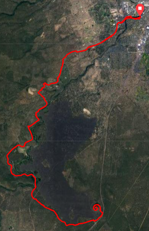
I left the Old Mill district and headed up towards Century Drive. Take Century Dr if you must, but the prefered route is the paved and gravel bike path just south of the highway. Follow this path and you will cross Century Drive twice via two very nice tunnels under the highway. The second tunnel, which puts you back on the south side, is near the Ranger Station. This is one option for parking if you do not want to ride from Bend.
Exit the tunnel and enter single track. This stretch is relatively gravel bike friendly. Only one rock drop that I had to hike my bike on. There are a plethora of single tracks and double tracks here. Choose your own adventure if you wish. Just make sure you are more or less heading southwest towards the Deschutes River. Continue following the cliffs above the Deschutes and take time to stop and check out the views, it's worth it.
Benham Falls is the big attraction along the way. Stop here and take in the sites from the overlook, then continue on. This is another "put in" to drive and make this ride shorter.
Cross the bridge over the Deschutes and it is a paved bike path all the way to Lava Butte. The road up Lava Butte was still closed to cars, which made for pleasant climbing up the cinder cone. Huff and puff your way to the top, the grade hits 10% in places.
I made my calls on 2 meters from the base of the fire lookout and quickly got my 4 QSOs with great signals into Bend and Terrebonne. I chatted with the ranger (no hanging antennas off the fire lookout, sadly) and found myself a tree for a wire. I tried to have my wire not over the hiking trail even though there was few people at the butte. This meant I was pointing more South than East. I spent about an hour on HF and only managed a single QSO. A summit to summit with K6EL (W6/NC-298) on 40 meters.
Time to pack it up. I made some final 2 meter calls and got two more stations before heading down. The descent down Lava Butte without cars is glorious. I hit 40+mph with ease. The ride home is gradual downhill now. I stopped and filtered water at the bridge near Benham Falls.
This is an out and back ride, so more or less follow the way you came to get back to Bend. Maybe choose a different single track to rip?
Again, there are almost limitless variations of this ride to shorten or lengthen, add or subtract difficulty. If you are interested in doing a ride like this, feel free to reach out via email. I'm more than happy to chat about options, trailheads, gear, etc.
The ride by the numbers: 39.4mi, 2271' gain, 3:02 moving time.
The route: https://ridewithgps.com/routes/35812347