(IMPORTANT NOTE! Everything in this post is true with the exception of the peak designation: W7O/NC-022.
As it turns out, David should use GPS coordinates to check his destination because the Elk Mountain that I thought I was climbing is here:
Latitude: 46.0539 , Longitude: -123.5644.
The peak that I actually climbed is here:
Latitude: 45.61628 Longitude: -123.4849
Astute observers will note that these coordinates are not the same!
Sigh.
The good news: My mistake cost none of the chasers any points; it just costs me mine.
Te better news: I still made a contact 75 miles away using FM with 5 watts!
So learn from me kiddies! Use your GPS coordinates to double check that you're "activating" what you think you're activating!")
I could have titled this post "A Very Bad, Really No Good Idea." OR "How Not to Do a SOTA Activation”
I had a couple of limitations for my first ever SOTA activation.
1. I only have an Yaesu FT-60R.
2. I had to borrow antennas for better range.
Originally, I thought that I might try to activate a peak and grab a quick overnight backpack trip. Indian Mountain is one eligible peak and the Indian Springs camp nearby has a water source. I checked out trail conditions online and finally landed on one of the Pacific Crest Trail resource pages. This resource page included a snowpack indicator. Said snowpack indicator showed that most of the trail and my prospective camp are likely under snow.
Well, darn.
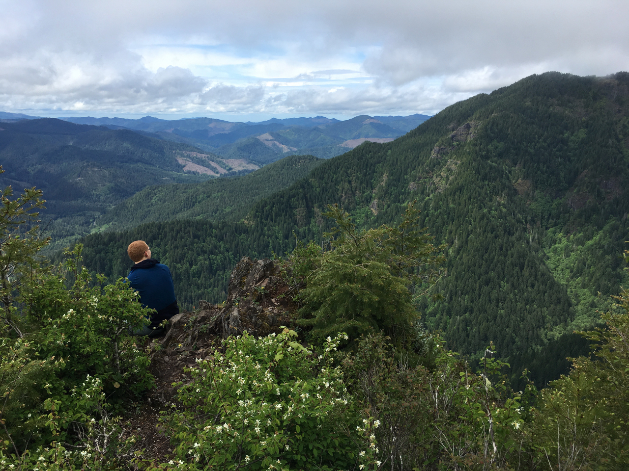
So I browsed through the map of SOTA-eligible peaks reasonably close to Portland that might give me a good hike if I couldn't make any contacts. I saw Elk Mountain on the list. I have not hiked The Elk Mountain-King Mountain Trail in a decade. I remember it being a good, stout hike with amazing views and a steep trail.
I had a reasonably good memory. I also had pretty terrible planning.
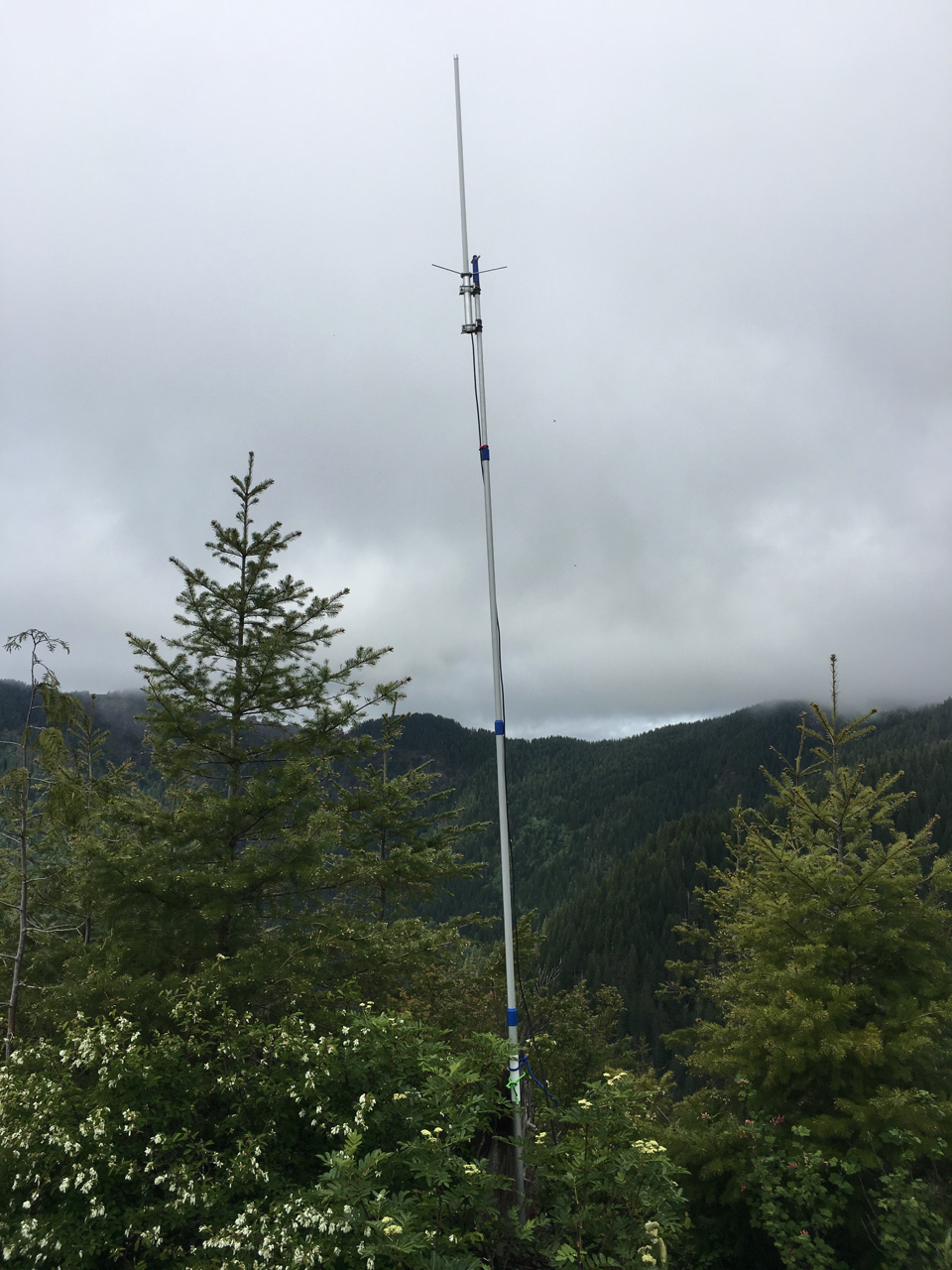
Due to some budget constraints, I couldn't obtain the roll up j-pole and fishing pole combo in time for my summit activation. So I borrowed a 16-foot painters pole and a Comet GP-1 Dual band ground plane antenna. I figured I'm a pretty stout hiker so that's not too much to carry, right?
Riiiiight. [shakes head]
I *had* forgotten exactly how steep the trail gets on this hike. I got very sweaty very quickly. The comet antenna strapped to my backpack kept knocking water off of overhead branches and onto me. Nevertheless, I made good time to the summit and arrived at 10:45 (17:45 UTC); well before I had scheduled myself to be there on my SOTA alert. I had my radio on while I hiked and I heard a group of guys doing an informal net on 146.52. They sounded like they were really having fun!
I listened to the hams ragchew while I found a good tree stump to use as an anchor and I got the antenna up in the air. I waited for a pause in their conversation and nervously keyed up. I gave my call sign and waited. I got acknowledged and I asked if they were interested in helping me with my SOTA activation. I shouldn't have been nervous; every time I've tried something new, other hams have always been great to me. This time was no exception. I got four contacts in four minutes and eight contacts total, including two Summit to Summit contacts. My signal got out as far as Ridgefield and East Vancouver, Washington. I even had one contact in East Portland though the ham told me my signal was “very scratchy.” Honestly, with the ridge line of Forest Park between me and Portland, I hadn’t expected anyone in Portland proper to pick me up. I also heard some hams out in Washougal, WA and Astoria,OR, though I was unable to contact them.
In between contacts, I made some coffee because, well, if your’e going to carry too much weight anyway, you might as well carry some luxury items. While I didn’t see many people on the trail while I was hiking, I did see 12 people on the summit. Every single one of them asked about the antenna. Almost every one of them asked if I had put up a weather station. I gave a spiel about amateur radio and Summits on the Air. Everyone seemed okay with me chit chatting on the radio. One hiker got very excited to listen to the exchanges.
After operating from 11:00 - 12:15 (18:00 - 19:15 UTC), I packed up and get ready to do the rest of my hike. I planned to go from Elk Mountain to King Mountain, and then down to the King Mountain Trail-Wilson River Trail junction. Then I would follow the trail back to Elk Creek Campground where I started. I planned poorly, as you will see shortly.
The hike over to King Mountain from Elk mountain is treacherous in places. Fun, but treacherous. I made it though the exposed saddle. And down the section of trail with some rope to help with the steep descent. And I made it through the constant up and up and up of the trail to the summit of King Mountain. I even found the one spot on King Mountain where you have some minimal cell phone coverage. I summited King Mountain at 14:15 PST (21:15 UTC). I got my obligatory summit picture and signed the summit log. I tried to make another contact with a friend just to see if we could. I was unsuccessful.
I started my descent and soon discovered my poor planning. While I had carried too much weight, not enough of that weight was food and water. I ran out of water in my hydration bladder. I pulled out my spare water bottle and soon ran out of that water, too. I had run out of snacks an hour earlier. Apparently, I had not accounted for 2 hours of sitting still when I planned my trip. Since I needed an extra two hours of food and water over what I normally packed for a hike, I ran short. I won’t make that mistake again. The descent from King Mountain is steep and unrelenting. A person might even describe it as grueling and doubly so when that person has no water or calories with which to refresh themselves. Even so, I made it down safely to the King Mountain Trail-Wilson River Trail junction at 15:25 PST (22:25 UTC) thirsty, hungry and tired. Another 90 minutes of rolling but well maintained trail brought me back to my car at the Elk Creek Campground at 16:50 PST (23:50 UTC).
I fairly well fell into my car and out of my hiking boots. I gulped down about half a liter of water at a go. I stopped at a convenience store on the way home and indulged in a Snickers bar, 20 oz of Mr Pibb and a bag of Chili Cheese Fritos. These items went a long way toward restoring me to something resembling a functioning human being.
For future SOTA Expedition, I plan to carry adequate food and water, and a much much smaller antenna set up. I want to thank all the stations who helped make my first SOTA activation successful. I had a blast and I might be hooked. Also, please let me know if this story was too long!
David AG7TW