
Summary - Red Mountain is an easy two mile, 1400 foot climb from the gate to the summit along a poorly maintained road. There is a lookout tower and a couple of VHF/UHF installations on the open summit. The views are amazing! FSR6048, the road to the summit, is in poor condition but passable with 4WD and clearance. The gate location shown on the USFS maps is incorrect, it is actually at 45.920, -121.824. There is only room for one vehicle near the gate. On the summit, there are a few trees for lashing a mast and working from the lookout tower walkway is a delight.
Long Version - I originally planned to hike both Red Mountain and nearby 4180 (Capacitor Peak, LC-071) but the view and operating position on Red Mountain were so fab that I lingered until the changing weather made the second hike seem a poor option. Though it is only mid-November, there was significant snow above 3000 feet in that part of the GPNF. Had it not rained this week, 6048 probably would have been impassable.
I got there by taking WA14 to Wind River Highway to NF-65 (turn at Old State Road then make an almost immediate left onto Panther Creek Road, which is NF-65) to NF-60 to FSR-6048. 65 is paved the whole way, 60 is mostly good gravel, and 6048 is dirt/sand that is rapidy eroding and crossed by at least one substantial stream. If you are going to drive to the gate at 45.920, -121.824 you will need 4WD and clearance to make it go. Two notes: there is a sign at the junction of 65 and 60 that says 60 is closed to motor vehicle traffic after December 1st; though the gate was open while I was there, it is usually closed and locked.
There is room to park one vehicle at the gate. If that spot isn't available, you find a couple of turnouts further back on 6048. The hike from the gate is about 2.2 miles long and a 1400 foot climb at a steady clip. The road up is mostly through open forest but gets enough wind for the snowpack to get very icy and crusty. In the winter (ie, after November 1st) carry microspikes, crampons, or snowshoes or enjoy a long, posthole-making slog.
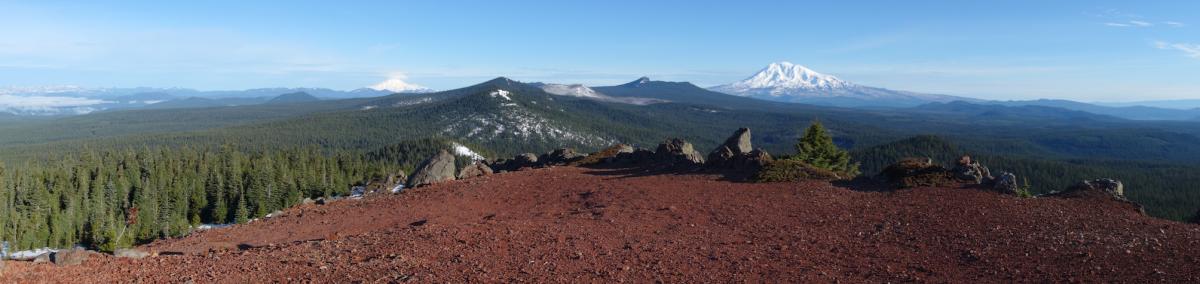
On the top you will find a boarded up fire lookout and a couple of VHF/UHF installations. The tower deck is open and a nice operating position. I didn't experience any interference from the communication equipment. The views are pretty awesome... south you will see Mt Hood and Mt Jefferson. North is Mount Saint Helens, Mt Rainier, Gifford Peak, and Mt Adams. The wind is also pretty awesome so a hard shell jacket and pants are handy if you are going to be up there for very long.
Here is the view looking north, with Berry Mountain, Gifford Peak, East Crater, and Lemei Rock in the center foreground, Mount Adams to the right and Mount Rainier to the left
I was able to spot using my cell phone so I didn't try APRS. It is easy to get an HF antenna up... I lashed a mast to one of the three small trees on the summit and ran an EFHW horizontally from there to the tower, found a cozy corner mostly out of the wind, and made a lot (for me) of contacts. Two meters, even with a halfwave whip, was relatively easy.
With a very nice hike and a terrific place to spend a day operating, this one is on my summer and winter "do again" list. If you want to get a couple of hills in one day, 4180 is nearby and there's a string of hills along NF-60, too.