
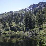
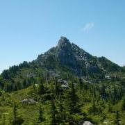
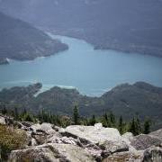
Our first activation of Bald Mtn in 2015 was very satisfying even on the overcast and misty day we did it. But opt for a sunny day if you can - the views at the top are really worth it. On a clear day, you will be rewarded with a wonderful vista of the Spada Reservoir and the mountains beyond. The pictures here were taken when we went back in 2016.
We hiked in on the Mallardy Ridge Cutthroat lakes Trail #706. To get there from

Granite Falls, follow the Mountain Loop Highway for about 17.8 miles to Mallardy Road (aka FR 4030). Turn right and follow the road 1.3 miles to FR 4032. Veer right onto FR 4032 and continue 5.7 miles to the end of the road and the trailhead. Parking here is limited to spots along the road.
The trail itself is moderately difficult, rooty and rough. I think it's about 5 miles to the peak. At the lakes, numerous side trails abound and it can be confusing. Generally follow the widest path down between the lakes then follow it south as it turns to climb up the ridge east of the peak.
There is one trail junction on the ridge, with it's sign laying on the ground. Take the lower path signed Bald Mtn & Ashland Lakes. It passes across the south slope and switchbacks up finally reaching a saddle just west of the peak. Leave the trail here and traverse under the cliffs back to the east side for the easy scramble to the peak.

Greentrails maps left a lot to be desired on this one. I printed out another map to follow.
Fred - N7KRN