The weather this week was looking like it would be good, so I wanted to get in my March summit. I wanted to make it a challenge of some sort, so I decided to go for my first first activation. The Olympic Peninsula has a fair number of unactivated hills still, and a lot of them are on USFS land. I started exploring and found Peak 1620.
On first glance on Gaia, it looked like this should be fairly easy. There was a good forest service road to the trailhead, then another forest service road all the way to the summit. The one to the summit was marked as maintenance level 1, or closed with basic custodial care only. I assumed there would still be a reasonably easy to follow path, and that was mostly correct.
The one element that did not completely hold up was the Gaia snow depth layer. It wasn't wrong per se, but I'm used to Gaia overestimating the snow depth by some amount. On several summits this winter the actual snow depth has been about half of what it was reported to be on Gaia, today it was roughly double. I guess it's still within a 50% margin, just the other way!
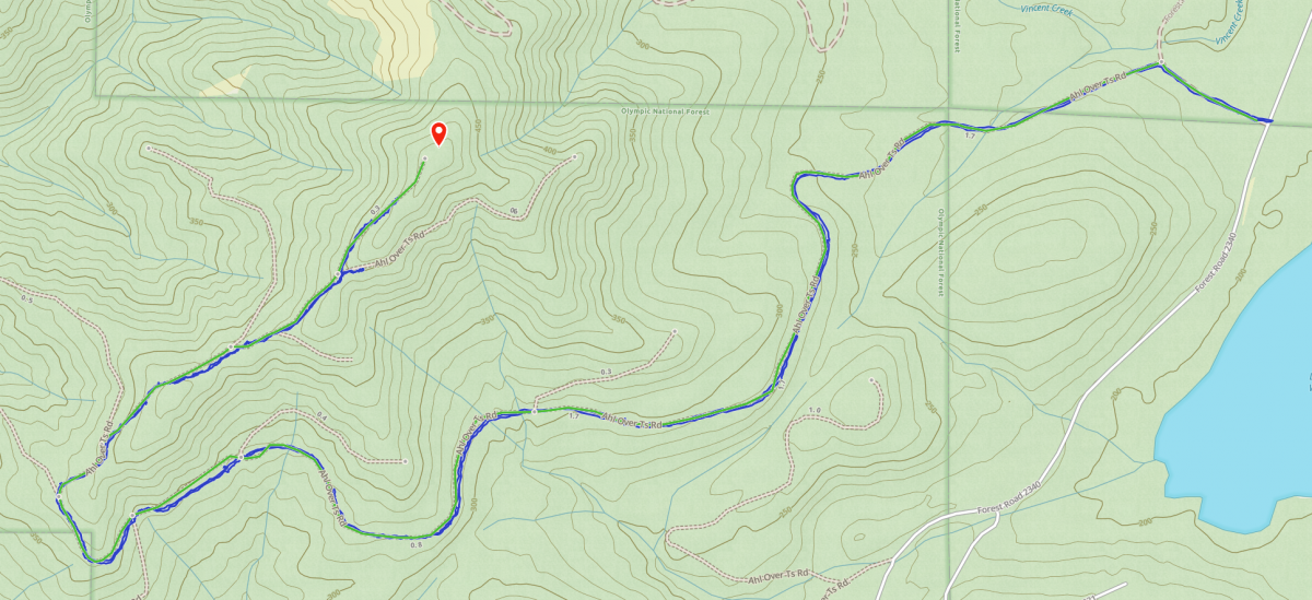
Anyways, I parked my car right at the intersection of FS2340 and FS2340-100, near coordinates 47.3592, -123.2847. FS2340 was a fairly easy although decently slow drive at times. It was entirely snow free but it is very rutted out and at times there is no way around the ruts. There are a couple ~100 ft long sections where I just slowed down to a couple miles per hour and rode them out. I think any car could make it though with careful route picking on the rough sections.
There are pull offs on both sides of the road at the parking coordinates. The road to the summit leaves from the north side, and you could easily park there and be well clear of the gate (which warns of towing if you block it), but the snow was high enough that I decided to just park off to the side of the main road. My car appeared to not be bothered during the day and no one else used this trail all day. During the summer I'd expect you could park 5-10 cars with ease on both sides of the road, and I doubt there are ever half that many people here.
The trail is open to all non-motorized vehicles including bikes, and a bike would make about half of the trail much quicker. Interestingly the signage below does seem to indicate that this is private property, but all land use maps show this as USFS land.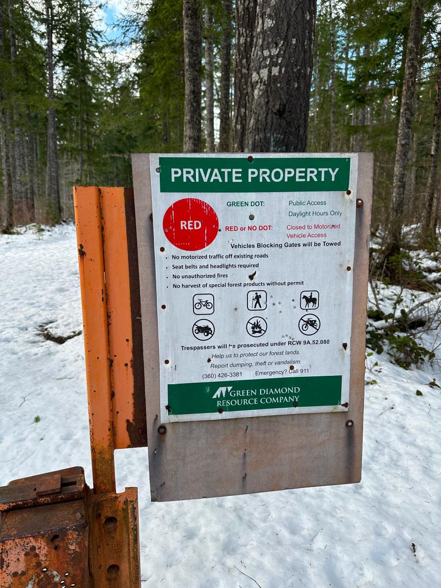
The trail was initially covered in about 3" of snow, enough to be a little annoying without snowshoes but not a big deal. After about 0.1 miles, take the fork to the left to start the very gradual climb.
The first mile and a half of the trail is quite easy, the level 1 maintainence forest service roads are in better shape than some level 4 "open to all passenger vehicle" roads I've been on. Around mile 1.5 though, that changes quickly.
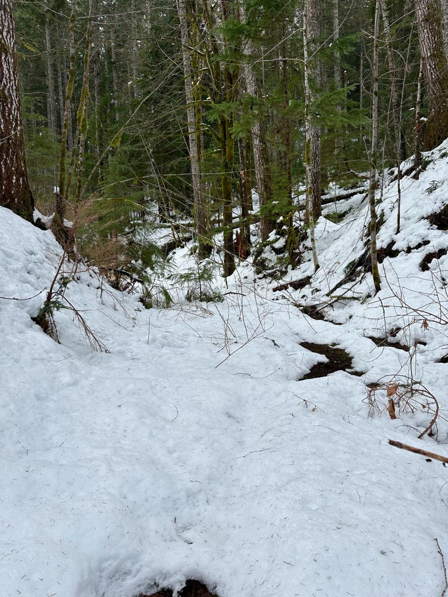
Most of the rest of the way looks like this or worse. I started post holing up to my knees and then deeper, and near the summit I was breaking trail up to my hips most of the way. Leaving my gaiters at home wasn't a good idea as my boots ended up totally full with snow (and therefore eventually water). The farther up you go the less maintained the trail is, and eventually it is virtually bushwhacking. There is one tricky turn near the very top, at the final fork in the road near coordinates 47.3567, -123.3081. The road to the right looks like a path but doesn't go to the summit. There is no road to the left, at least not in the winter, but that's the way to go. I went the wrong way and after bushwhacking through thick young growth pine I decided to check the maps, and then found a way over the ridge back onto the correct road.
I ended up making it into the activation zone with a little bit to spare, and then stopping well short of the summit. I was totally done, fully exhausted, soaking wet, and very frustrated. But, I made it! On the way up Chris, WX7EMT, was calling on 146.56 FM. I heard him on my HT and chased him, letting him know I was hustling to the top, but you can only go so fast while breaking trail in waist deep snow. Alas, he headed down about 5 minutes before I made it to the AZ, but he was my first chaser.
I decided I wasn't sticking around long enough (and breaking more trail) to put up a wire antenna, so I set up the trusty Elecraft AX1 with my KX2. In just a few minutes I was running and quicklly got a S2S with Amy, AG7GP. Several local chasers followed on 40M CW before I switched to 15M as it's been treating me well recently. I got a quick 14, including 7N1FRE in Japan and F4WBN in France.
After about 40 minutes stationary on the summit, my soaked feet were simply too cold and I called QRT and packed up. I think I made record break down time, I started moving down trail within 3 minutes of calling QRT. I was ready to be done! Fortunately heading down was easier than heading up as someone had very kindly broken trail for me, hi hi.
Overally, my first FA was successful. It was very frustrating at times, but I did go out seeking a challenge after all! I'm glad I got out on a nice March day, if even for a one pointer. For anyone stumbling upon this looking for a good one pointer in this area, there are others that are much better. This one is probably best reserved for anyone seeking new uniques or to get a complete if you chased me today! I don't know if I'll be back, but I'm glad to have crossed this one off the list.