
North Grand Ridge is an easy summit to activate with a short (3.4 mile RT, ~600' elevation gain). The summit might be considered part of the "Issaquah Alps" series of summits that include Tiger Mountain, West Tiger Mountain, South Tiger Mountain, Taylor Mountain, and Rattle Snake Mountain. This report provides details on how to legally access the activation zone (AZ) and summit.
Josh (WU7H) and I activated this summit on 27 January 2019. Earlier in the day we had activated Taylor Mountain (W7W/KG-118) and we were looking for another quick summit to activate on the way home. This one did the trick. We were able to activate it without doing any serious pre-planning, but John (K7JRO) had shared this route with us.
The summit and trail system around it are all on King County property. The trails are part of Grand Ridge Park. The trail system is mixed use, so some trails are legal for mountain biking. Other trails are pedestrian only. The summit itself is located in the Mitchell Hill Connector Forest.
There is some confusion about access to this summit because the shortest access to the summit is from the south through a private neighborhood that is posted against trespassing. Access via that route would require a short hike of 100' or so and maybe 20' of elevation gain before entering the AZ. Don't try going this way unless you have permission from a duly authorized person.
Fortunately, public access to the AZ and summit are available from numerous trail heads in the Grand Ridge Park system. Perhaps the easiest hike starts at the very end of the public road heading up to the Grand Ridge neighborhood at 47.54447, -121.9685. From I-90 just east of Issaquah, take the High Point Way (Exit 20) to the north. Continue on SE High Point Way to 280th Dr SE and turn left. Follow 280th Dr. SE for 0.6 miles to the end of this road. Don't turn onto SE 63rd Street, as that is a private road.
There is room for a car or two to park. You will find the trial head (well signed) behind some concrete barriers.
The trail system for Grand Ridge Park is available on Open Street Maps and other variants like Open Cycle Maps. It is a good idea to have a map or a GPS with a trail handy as numerous trail intersections can become confusing. Essentially, you want to turn right at every major junction and you end up on the Grand Ridge Summit Trail. The high point of that trail is at about 47.544466, -121.968495. At this point you will be at 1,342' and the summit is at 1,422'. So you are barely in the AZ. You can bushwhack NE toward the forested summit if you wish, but the high point of the trail is good. I believe all trails on this route are open to pedestrian traffic only (i.e. no bicycles or horses).
Here is map showing the parking spot, trail, summit, and the private property area to avoid.
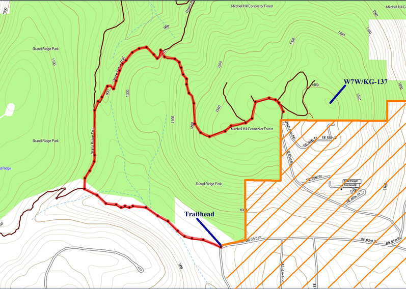
(A full size version is available here)
Note that the map shows another trail that goes up to the summit. I've not seen that trail in my two visits to this summit. We activated from the high point on the main trail.
Return by retracing your steps. The trail continues another 100' or so to the south and ends in a private neighborhood with "no trespassing" signs.
There are numerous alternative trail heads to access the Grand Ridge trail system. One alternative that I have tried is to start in Issaquah's Central Park (47.54319, -122.00012) and pick up the trail here: 47.5390, -121.9999. I don't recall the distance to the AZ from this spot, but it is probably on the order of 7 miles round trip and probably 800' of elevation gain. Mountain bikes are allowed on the trail for much of this route. And biking this trail seems popular.
The summit is a bit sketchy on 2m (at least it was near the perimeter of the AZ). Josh and I were able to squeak out 4 QSOs on 146.52, but it wasn't easy. The first time I activated this summit, it was a similar story on 2m. If you have it, consider hauling your HF gear to this one...just in case.