Access is via the Klootchy Creek County Park off of HW26 just 2 miles east of Hwy 101 near Seaside. There's plenty of parking. And a pit toilet.
The summit and access are on Nuveen Natural Capital (private) property, previously Lewis and Clark Timberland. A (free, as of 2025) access permit is required from https://nncpermits.com/ Get the one for NNC_OR_25.
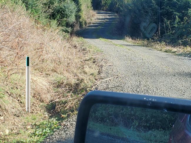
As of Nov 7, 2025 they instituted the "Green Dot System", whereby you're allowed to drive on roads marked with Green Dots (see photo below), and park up to 100 feet on any spur connected to a Green Dot Road.
I went during hunting season and the access gate at the park was open. Not sure, but it could be closed at other times of the year. The roads were easily priusable.
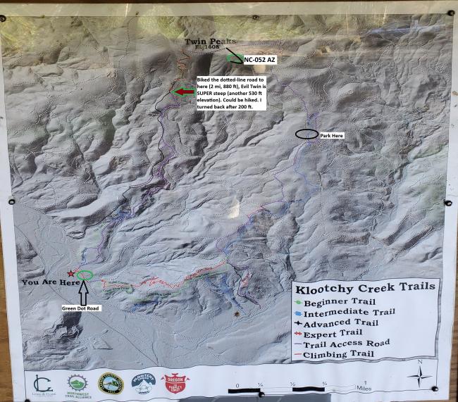
From the park (whether driving or riding a bike / hiking) proceed from the parking lot to the road marked "Green Dot Road" (see image below) and follow this road for 2 miles, 700 ft elevation to the "Park Here" marker I added to the map below, which is a road that does not have a green dot, so you're limited to 100' from the main (green dot) road.
From there, walk or ride a bike another 1.1 miles, 700 additional feet of elevation gain, to a sharp left hairpin turn onto the road drawn with a dark black line. From there, circle around clockwise, climbing 140 feet, to the end of the road. From there it's a short bushwhack of maybe 100m and a few tens of feet climb through a field of debris from recent logging operations.
From the parking area to the summit is about 3.2 miles and a gain of 1400 feet.
If you ride a bike from the park to the top, you can attempt the many downhill MTB trails.
UNNECESSARY, SUPERFLUOUS DETAIL:
I initially rode my bike up the purple gravel road to the red/green arrow, planning to ride up Evil Twin MTB trail. Impossible. I met a guy coming down who said he climed it once. Sure. Maybe without a bicycle. Fearing I would miss all out on S2S contacts, I rode back down to the truck, loaded up the bike, and headed up the next road to the south, which I marked with a green circle. As you can see in the below photo, it's marked with a green mark, meaning it's OK to drive. Proceed to the black oval I labeled "Park Here", because that spur road does *not* have a green dot (or, better, no green rectangle), so travel is prohibited beyond 100 feet. I then rode my eMTB (Class-1 only) up to the road I marked with a thick black line (not on the map), which went to just below the AZ (1.5 miles, 735 ft elevation). From there it was a bushwhack through recent logging debris to the summit, some tens of feet of elevation change.
Now that I examine the map, it appears that the purple road goes all the way up from "Park Here" (with a little jog), but I don't remember seeing another green dot where the purple line met the road I was traveling on. So maybe you can drive all the way to the black line road (but that was definitely not marked with a green dot, so drive only 100 ft on it if you're able to get to it). Buyer beware. I was told by a MTB rider that violations (distributed by the police) can cost you many hundreds of dollars in fine (for trespassing, I suppose), so be aware of the rules (which you'll read when you get your permit).
The views were tremendous of Saddle Mountain to the N, Onion Mountain to the S, Seaside and the Pacific. Really nice. Plus, there are a number of mountain bike trails, which a group maintains on the 1st Sunday of every month, according to someone I met on the road.


