Broken Top is an eroded stratovolcano about 25 miles west of Bend Oregon in the Three
Sisters Wilderness. It can be reached by traveling to Mount Bachelor on the Cascades
Lake Highway (County Hwy 46) and then continuing west towards to the Green Lakes/Fall
Creek trailhead. Round trip to the summit and back is about 12 miles. The summit reaches
an altitude of 9175 feet.
A Northwest Forest Pass is required to park at the trailhead, or a one day pass can be
picked up at the trailhead for five bucks. A no-cost permit for entry to the wilderness
area is also required.
Each year at Christmas, our family tries to focus on the giving of ourselves and not the
giving of things. For several years now, my oldest, Andrew, has given me the gift of presence
(not presents) with some sort of outdoor adventure. This year I decided that he could put a
little more spice in our adventure and somehow we landed on trying to climb and activate
Broken Top.
In my youth, I had some good adventures on big mountains. I had a lot of fun, scary times
on multi-pitch rock climbs in Tennessee and Western North Carolina. But as the years past,
my high-angle abilities diminished. The demands of family, work and community take a toll.
I had begun to wonder if my season of high-altitude fun may be coming to a close. Fortunately,
this trip painted a brighter future. This old goat still has some "go" in him.
We took a very pedestrian (10:30am) start. We meandered up the Green Lakes trail for about
four miles thorough some of most beautiful terrain I've seen in Oregon. A rushing river,
waterfalls, big timber and the looming hulk of South Sister glowing in the morning light.
The trail was very nice, well graded and not steep at all.
When we reached the Green Lakes camping area, we took the trail that went between the smaller
lake to the right and the bigger one to the left. This is roughly straight towards a saddle
between the northern summit of Broken Top and the unnamed 8040ft summit just to the northwest.
This way up is also known as the northwest ridge route; ascend to the saddle, then go directly
towards the summit.
We took the short trail that took us towards camping site 16. Just before meeting the campsite,
we turned left aiming towards the saddle. Here, the trail here becomes very steep with no
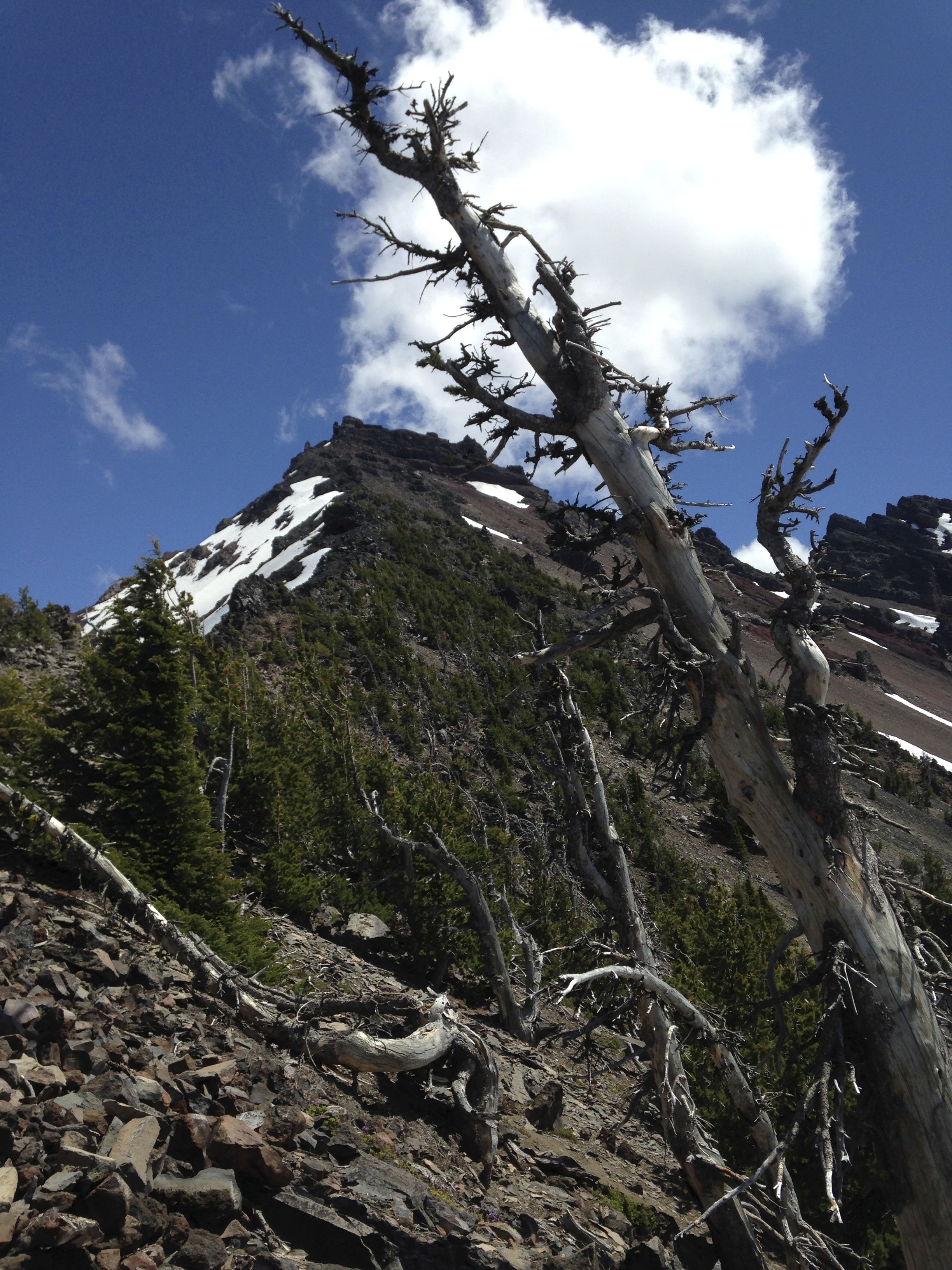
switchbacks, only small "S" curves. We passed through several snow fields and increasingly
steeper terrain.
At the saddle, you climb the northwest ridge directly towards the summit. At this point you will
begin to encounter terrain that has substantial exposure and lots of loose rock. I had trouble
not feeling unstable at times which was embarrassing, but I understand is normal for those of us
approaching 60. It was a funny, unbalanced feeling that I couldn't explain. I just had to fight
through it and keep going.
At many points when you look up the ridgeline, Broken Top looks simply impossible to climb. It
looks far too steep and vertical for there to be a path to the top. But you simply keep solving
each problem, one step after another, get over each ledge and just keep trucking. I had a great
guide in Andrew who kept encouraging his dad and being patient as I struggled with my equilibrium.
Honestly, I was hoping that I could simply reach the AZ, setup shop and then get the heck down.
But that was not to be. Near the top (last ~100ft) there are a series of crux moves. At each one,
I'd check the GPS altimeter and see that the AZ was not yet in reach. The first move is a 10-15
foot high, 5-inch crack to a ledge. Its an easy climb, maybe a 5.1, except that a fall would result
in a "high-speed descent" with certain death. Andrew belayed me over this obstacle and I hoped that
I would be in the AZ. No luck, still not there.
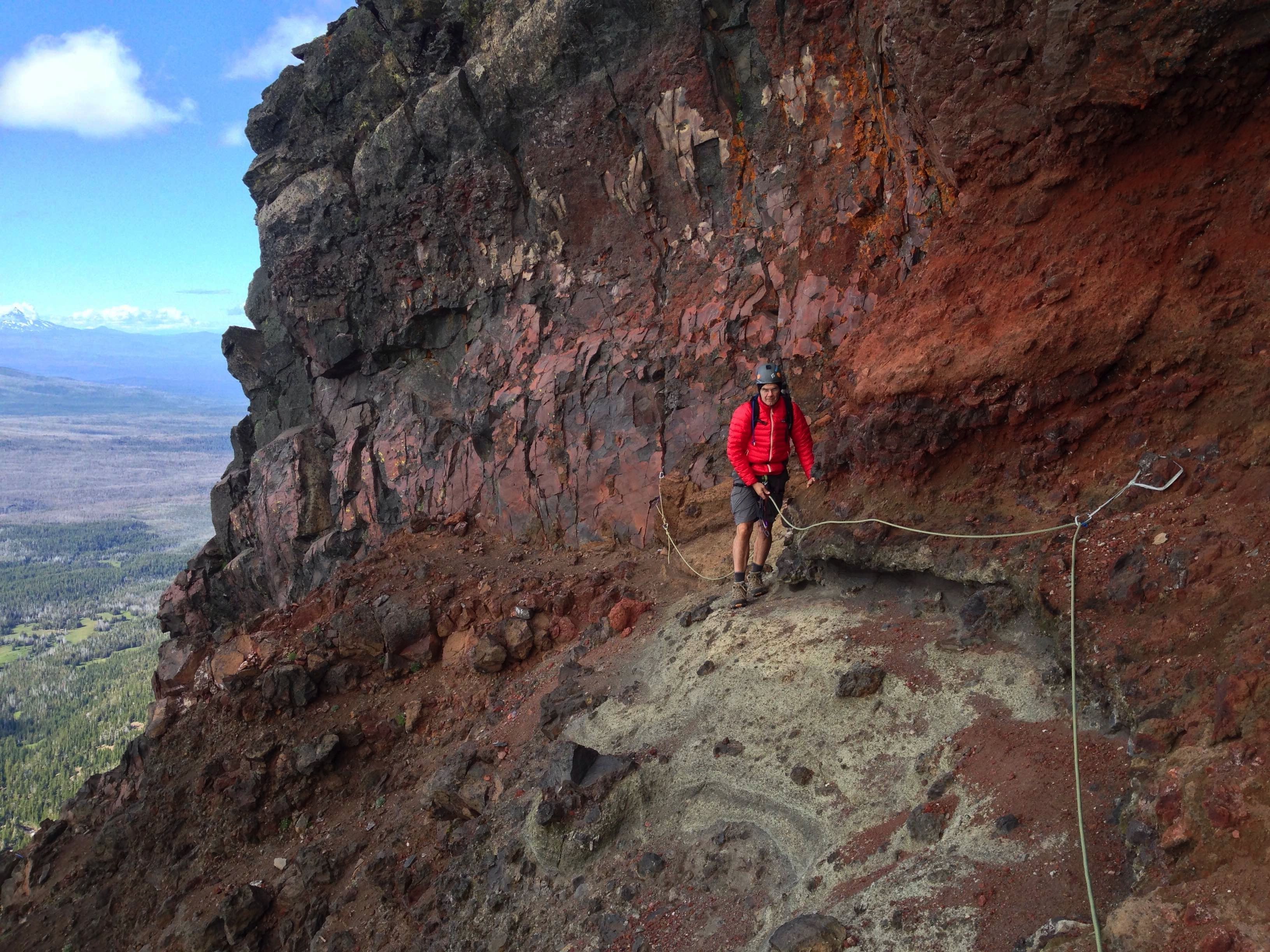
The next "interesting" spot is called the "catwalk". Its a 75ft long, sloping, narrow walk to the
end of the upper summit area. The rock is better here but that's not saying much. The surface is
gritty and a slip here would definitely end the day. Fortunately, Andrew set up a fixed rope system
for me with a prusik knot and the catwalk was easily traversed. Honestly, its an easy walk. You
just have to be confident in your footing and balance. You cannot second guess your footing or loose
your nerve.
Finally, we round the upper summit area and are looking at the summit block. The walk to the summit
block has one hairy spot where the path is about 18 inches wide and its sheer on both sides. There
is nothing to grab if you should slip. I had to really suck it up to cross it.
The summit block is the last crux move and has the best rock on the mountain. Its about 15 feet high
and is probably a class-four climb at most. But again the exposure is substantial. Once I was up on
the summit, I could not believe I had done it. So stoked. I had been pretty gripped at times but now
that was replaced by deep pleasure and gratitude.
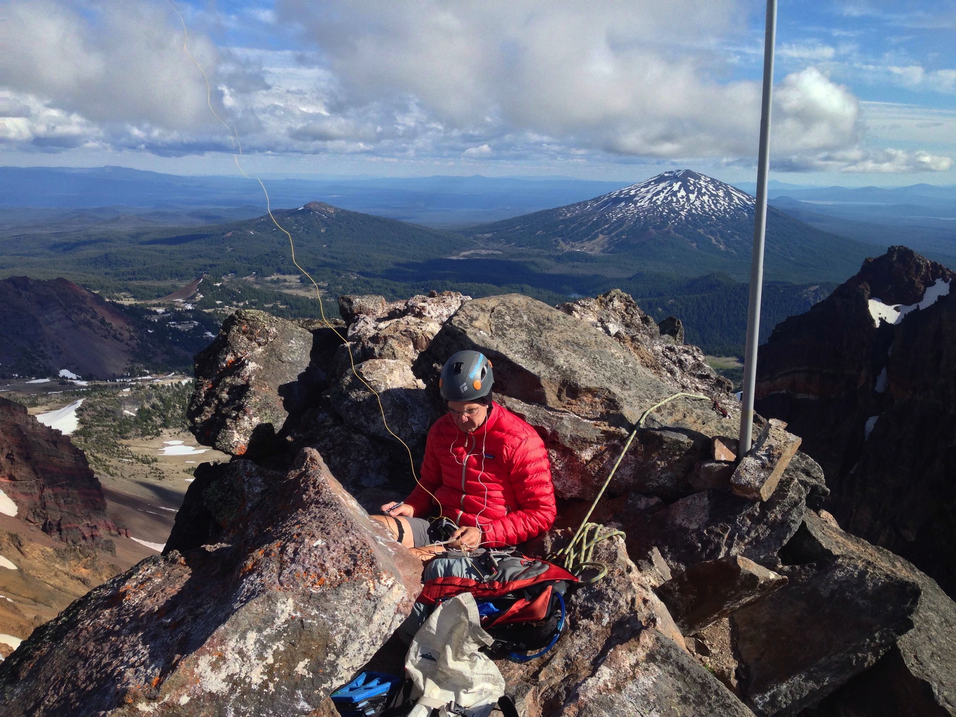
On top we quickly setup the EFHW. I had cobbled up a quarter wave groundplane just in case the wind
were too high. But winds were mild and we were able to wedge the 33ft SOTA pole in a crack and fix
it into place with some summit rubble. It was pretty cold for July, maybe 45 deg. with winds at maybe
10mph. The summit is very small and strewn with large loose rocks. There is ample room for maybe 5-6
people on top. Its an area roughly the size of a dining room nook.
After the catwalk I had tried to take a picture with my phone. It was apparently bricked and was
asking for reactivation. I wasn't in the state of mind to remember my Apple ID and password, so
Andrew had to self spot me on Sotawatch as I was hours late on the activation and calling CQ with
no takers.
Fortunately, we self-spotted and shortly afterwards the chasers came in. Thank you SO MUCH chasers!
I worked a bunch of stations from Alaska to Georgia to Maine then shut down. The match on the EFHW
was better than I've ever seen. Maybe its that the antenna was essentially a needle on top of another
needle. Was a blast that activation was!
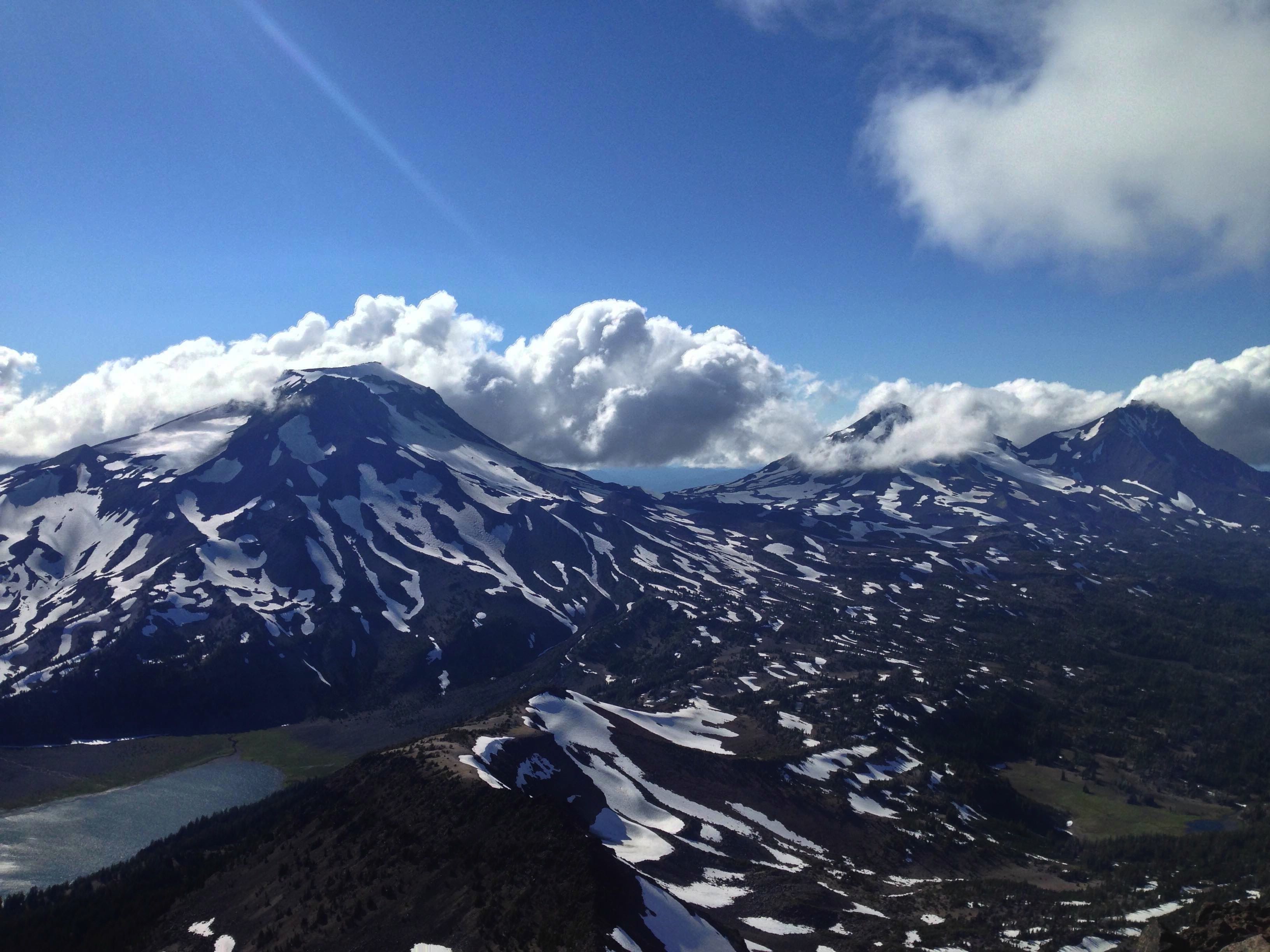
The views from to summit are stunning. South Sister is right in your face. Clouds were passing over
us and S. Sister during the day making amazing patterns. Absolutely jaw dropping. Its such a surreal
experience to be there.
Heading back down, I felt so much different; so much more confident. I was able to place my feet
without using handholds and walk with confidence even when looking down (way down!). It seemed that
an old rhythm had mostly returned to my body and mind. Maybe I've got a few more days in the high
country left in me.
We carefully picked our way back off the ridge and back down to Green Lakes by 8:30pm. We ate our
last snacks and headed back to car, four miles away. We got back to the rig about 10:30pm with
headlamps. A truly fantastic Christmas gift.
If you decide to try Broken Top, heed K7ATN's advice. This is a serious mountain. If you are not
used to high-angle climbing and the associated dangers, enjoy some other summit. If you are capable,
this is a wonderful mountain to climb and activate.
I am in deep gratitude to my son Andrew. I would have never attempted this summit without his support.
He has become the accomplished mountaineer and teacher that I had always hoped to be. He is patient
encouraging, extremely careful and competent. I am deeply proud of him. You can read of his (and
Corie's) mountaineering travels at: http://www.mountainrefugees.com. Thanks Andrew, the teacher
has become the student.
For more information on climbing Broken Top, see:
http://www.summitpost.org/broken-top/150574