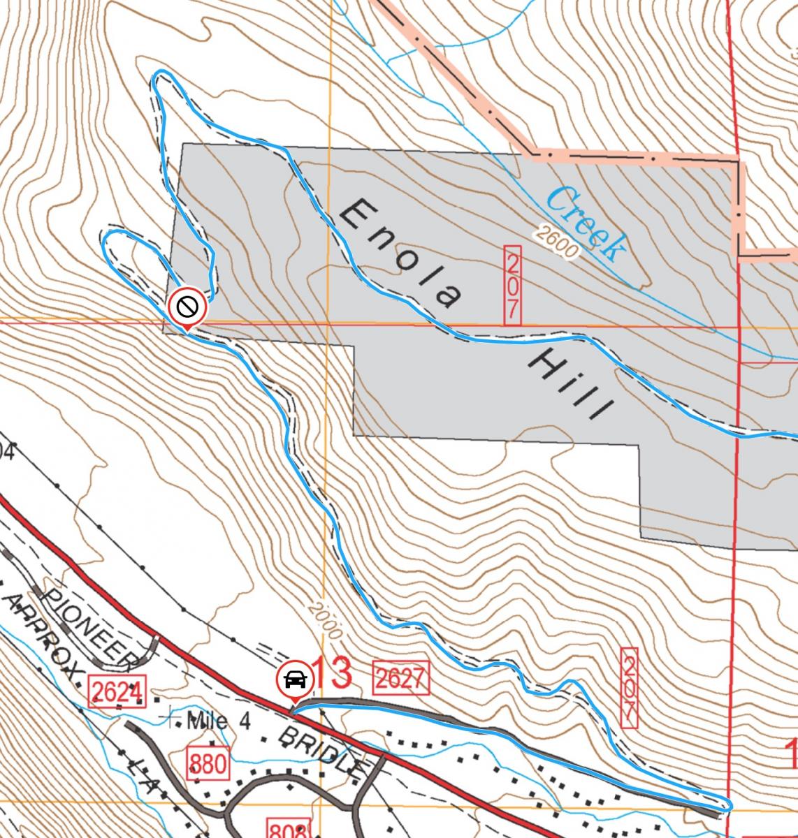
W7MTB's picture

Ball Butte, OR | September 2023

Summit: 
W7O/CM-007

FS-370/380 are both unmaintained roads and high clearance/4WD vehicles are highly recommended. FS-370 from Todd Lake to the intersection with FS-380 is passable in a less capable vehicle but FS-380 is very rough. I have driven both in the past in a front wheel drive Honda Element and we did see several passenger cars in the parking area but you have been fairly warned. There is not an established trail and the approach involves some steep and loose cinder slopes. I would classify this as an intermediate to advanced hike, requiring good fitness and route finding skills.

K7WXW's picture

signal peak wa | september 2023

Summit: 
W7W/LC-110

Summary - A drive up on the west end of the Toutle range.

K7WXW's picture

spud mountain wa | september 2023

Summit: 
W7W/LC-042

Summary - A short but very steep scramble up game trails will get you to the top of this very visible summit in the Toutle Range.

K7WXW's picture

castle peak wa | september 2023

Summit: 
W7W/LC-046

Summary - a soaring rock summit visible from 4562 with awesome views of MSH, Castle Lake, Mount Adams and Mount Rainier. The summit road is 2WD friendly and the hike is steep but short. Bring a mast and don't count on two meters for contacts.

K7WXW's picture

peak 4562 wa | september 2023

Summit: 
W7W/LC-051

Summary - At the end of a long drive along the ridge of the Toutle Mountains, a short hike brings you to the open summit with terrific views of Mount Saint Helens and Mount Adams. Bring HF gear and assume VHF contacts will be rare. ATT service is very good, as is APRS. The roads, up to the summit drive are 2WD friendly; the last bit requires high clearance and AWD or an additional quarter-mile of hiking.

K7ATN's picture

Peak 4700, WA | Sep 2023

Summit: 
W7W/PL-064

Just east of Mount Rainier National Park and north of Highway 12 is this bushwack activation.

KI7EMX's picture

Peak 8740, Idaho | September 2023

Summit: 
W7I/CI-061

Peak 8740 was first activated a month ago on 08 Aug 2023 by KJ7GRQ and N0DNF. This is a very straightforward “trailhead” from a rough dirt/gravel road.  Definitely not Prius friendly and I wouldn’t take anything but a vehicle with more than standard clearance.  Recent rains have created water channels, mud puddles and exposed rocks in places. 4WD is not required, however.

N0DNF's picture

Peak 7204 IDAHO 8/29/2023

Summit: 
W7I/SI-141

From Pocatello Idaho go South on I-15 until you reach the McCammon Idaho exit. From there take highway 30 towards Lava Hot Springs.  Before you begin your accent up Fish Creek pass heading to Soda Springs Id you will see a highway sign saying Blazer Hwy on your left before you cross the Portneuf River.  Take this old Hwy  North approx 9 miles.  You will see a FS sign saying Big Springs Camp Ground.  Take a left on the Pebble Creek Rd that heads to the campground. Before you reach the campground you will see a road to your right call Long Gulch Rd on maps...

N0DNF's picture

Peak 7180 IDAHO August 23, 2023

Summit: 
W7I/SI-142

From Pocatello Idaho go South on I-15. Turn off onto Highway 30 towards Lava Hot Springs.  Proceed to the Lava Hot Springs golf course and take Smith Canyon Rd South approximately 3.2 miles until you hit the Forest Service Boundry at 42.54653, -112.06385. There is no trailhead so you will have to park safely on one of the nearby pullouts.

N0DNF's picture

Peak 7060 IDAHO August 12, 2023

Summit: 
W7I/SI-227

Proceed South from Pocatello  Idaho to Mink Creek Recreation area. Traavel South  on the main Mink Creek Rd. which turns into South Mink Creek.  On your right hand side heading south you will see a ORV turning right (42.70139  -112.43832). This ORV road is Clifton Creek which takes you to Elk Meadows.  You will take this road approx. 6.2 miles.  At 42.74659 -112.47098 you will come to a junction of roads.  Here you will begin your hiking approach to the summit.