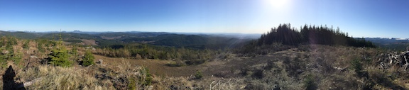
Blogs

AG7GP's picture

7156, OR July 2020

Summit: 
W7O/CE-245

This was meant to be the last of our 3 night expedition (although I did manage to sneak one more in :) ). This summit was not in my notes but on our way out after packing up camp, we decided to at least take a peak. It was a nice morning hike. Lots of wildflowers. Plenty of area to set up. There is also a large domed rock to view to the east on I guess would be it's false summit. There was also a lot of hooting from the blue grouse.

AG7GP's picture

6435, OR July 2020

Summit: 
W7O/CE-255

This summit I went ahead to give a try after deciding Fishhole Mountain nearby was not an option for the day. This little summit ended up being a very nice, peaceful stroll. Robin wanted to rest so I took the hike up solo after we had enough pinstriping of the truck and it ended up being about 2.25 mile RT hike. The top is a forested park like area. There are also grown over old skid rows that make for an easy hike, not really any log hopping. Plenty of area to set up and enjoy the magnificent view looking down at the brilliant blue Butcher Flat Reservoir.

AG7GP's picture

Dog Mountain, OR July 2020

Summit: 
W7O/CE-036

We had a couple delays getting to Dog Mountain but it was our own doing. We came from the east side opposite Dog Lake and took a road up which was not a proper access anymore. Burn scar, landslides and unmaintained roads made it impossible, and dangerous. You must enter from the west side of the mountain on Dog Mountain Rd. If you drive to the very top it is tight for parking. When we arrived the lookout was manned by a young man Lance who was very welcoming and let us set up on the lookout balcony.

K7FOP's picture

Red Mountain

Summit: 
W7W/LC-036

"Trailhead" for Red Mountain has been moved. Etienne's trip report is here. Follow his directions but now drive Road 6048 to   45.9186° -121.8189° and a gate (the last half mile or so of this road is not very Priusable). This makes the RT about 4 miles and 1300 feet of gain. There's a spot for 2 cars, maybe 3 or more if others agree to let their car be blocked in. Less hiking now. Or you can still opt to park at the old trailhead and walk the road.

W7EEE's picture

Wilderness Peak | July 2020

Summit: 
W7W/KG-132

My second SOTA required a longer hike (~2 miles each way) than Mt. Electric but was also a lot of fun.

AG7GP's picture

6650, OR July 2020

Summit: 
W7O/CE-252

This was the last of three for the day. By this time my memory is getting a bit blurry. We took RD 3780 off of RD 28. Hiked on the overgrown roads that are on some maps (3780 320) until it looked good to start climbing up. A lot of burnt timber on the mountain. Combination of boulder patches and timber but plenty of room. de AG7GP

AG7GP's picture

6370, OR July 2020

Summit: 
W7O/CE-257

This was number 2 for the day. A short hike but only if you are interested in driving through some brush. Walking the road wouldn't be bad though. Plenty of area to set up. This was a short and sad activation as we were informed of Robin's cousin passing while on top.

Take access road off of main road 28. 28 is main FS road that is paved.

AG7GP's picture

6490, OR July 2020

Summit: 
W7O/CE-254

This was where we chose to camp for our multiple summit trip, just at the northern base of the mountain, in a nice forested flat, just a jog up RD 105, the road is blocked a little further up. Where we camped is also about where you want to hike up the summit. Nice hike but we got really tangled up going down the mountain too far down the NW ridge rather than the face of the ridge and were caught in solid buck brush. Check satellite images to avoid, if you avoid this its about a 1.75 mi RT hike in a mixed forest with lots of Sugar Pine in a blanket of Indian Paintbrush.

AG7GP's picture

Cougar Peak, OR July 2020

Summit: 
W7O/CE-010

Cougar Peak was another summit for the day I thought there may be better access on than there really was. Instead it was not much better than Yainax Butte which I did earlier in the day. There is a trail or road going up that can make for a good hike. It is an unusual mountain of piled shale. We drove further up than most would choose to. Steep drop off, brush in narrow road, driving on large flat shale, and 3 point switchbacks. My designated SOTA driver, Robin N7HAP, goes the extreme sometimes!

AG7GP's picture

Yainax Butte, OR July 2020

Summit: 
W70/CE-026

Yainax Butte, or as the surveyor pin says, “Yonna”, was a mountain I was hoping to drive up to the lookout and do a quick activation on my way to SOTA campout/"expedition" in the Fremont NF west of Lakeview. The roads were awful. There are a couple ways to get there, just follow the maps but once you get to the main access road to summit, it is extreme 4wd rutty, rock crawl for about 3 or 4 miles. We ended up going all the way but I do not recommend it. It would be better off as maybe a  day hike up rather than drive.